Back كوينتن (بنسيلفانيا) Arabic كوينتن ARZ Quentin (Pennsilvània) Catalan Квентин (Пенсильвани) CE Quentin CEB Quentin (Pensilvania) Spanish Quentin (Pennsylvania) Italian Quentin (Pennsylvania) LLD Quentin (Pennsylvania) Dutch Quentin (Pensilvânia) Portuguese
Quentin, Pennsylvania | |
|---|---|
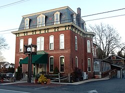
 Quentin Tavern on W. Main St. | |
| Coordinates: 40°16′46″N 76°26′23″W / 40.27944°N 76.43972°W | |
| Country | United States |
| State | Pennsylvania |
| County | Lebanon |
| Townships | West Cornwall |
| Area | |
| • Total | 1.09 sq mi (2.83 km2) |
| • Land | 1.09 sq mi (2.83 km2) |
| • Water | 0.00 sq mi (0.00 km2) |
| Elevation | 560 ft (170 m) |
| Population | |
| • Total | 755 |
| • Density | 691.39/sq mi (266.87/km2) |
| Time zone | UTC-5 (Eastern (EST)) |
| • Summer (DST) | UTC-4 (EDT) |
| ZIP code | 17083 |
| FIPS code | 42-63160 |
| GNIS feature ID | 1184550 |
Quentin is an unincorporated community and census-designated place (CDP) in Lebanon County, Pennsylvania, United States. It was named after Quentin Roosevelt, youngest son of President Theodore Roosevelt. The population was 594 at the 2010 census,[3] up from 529 at the 2000 census.
- ^ "ArcGIS REST Services Directory". United States Census Bureau. Retrieved October 16, 2022.
- ^ "Census Population API". United States Census Bureau. Retrieved October 16, 2022.
- ^ "Total Population: 2010 Census DEC Summary File 1 (P1), Quentin CDP, Pennsylvania". data.census.gov. U.S. Census Bureau. Retrieved October 16, 2020.

