| R671 road | ||||
|---|---|---|---|---|
| Bóthar R671 | ||||
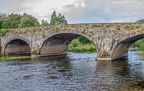
 Gashouse Bridge carries the R671 over the River Suir in Clonmel | ||||
| Route information | ||||
| Length | 55.4 km[1][2] (34.4 mi) | |||
| Major junctions | ||||
| From | ||||
| ||||
| To | ||||
| Location | ||||
| Country | Ireland | |||
| Highway system | ||||
| ||||
The R671 road is a regional road in Ireland. It travels from Clonmel, County Tipperary to the N25 road in County Waterford, via the villages of Ballymacarbry and Clashmore.[2] It follows the route of the former national trunk road T27. The road is 55.4 kilometres (34.4 mi) long.[1][2]

