| RAF Bowes Moor | |
|---|---|
| Bowes, County Durham in England | |
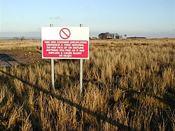
 Sign at RAF Bowes Moor | |
| Coordinates | 54°31′34″N 2°01′48″W / 54.526°N 2.030°W |
| Grid reference | NY982145 |
| Type | Military |
| Code | 588 |
| Area | 564 acres (228 ha) |
| Site information | |
| Owner | Air Ministry MoD |
| Operator | Royal Air Force |
| Controlled by | Royal Air Force (1941–1947) |
| Open to the public | Limited |
| Site history | |
| Built | 1941 |
| In use | 1947 |
| Fate | Derelict |
| Garrison information | |
| Occupants | No. 81 Maintenance Unit |
RAF Bowes Moor was a chemical warfare agent (CWA) storage site run by the Royal Air Force during and after the Second World War. The site was to the north of the village of Bowes in what is now County Durham, England. The Bowes Moor geographical feature runs from the north to the south west of the village. The Royal Air Force used the site to stock its chemical weapon supply, most of which was disposed of in situ by burning. The site, which closed in 1947, is known for the dangerous chemicals which leached into the soil.
The only unit to have officially worked at Bowes Moor was No. 81 Maintenance Unit RAF (1941–1947). The Bowes Loop of the Pennine Way goes through the site.

