Back Readanorascīr ANG Радноршър Bulgarian Sir Faesyfed Breton Sir Faesyfed Welsh Radnorshire German Radnorshire Spanish Radnorshire French Radnorshire FRR Radnorshire Italian Radnorshire Kurdish
| Radnorshire Sir Faesyfed (Welsh) | |
|---|---|
| Area | |
| • 1831 | 272,128 acres (1,101.26 km2) |
| • 1911 | 301,165 acres (1,218.77 km2) |
| • 1961 | 301,165 acres (1,218.77 km2) |
| Population | |
| • 1831 | 24,651[1] |
| • 1901 | 23,281 |
| • 1971 | 18,271 |
| Density | |
| • 1831 | 0.1/acre |
| History | |
| • Created | 1536 |
| • Abolished | 1974 |
| • Succeeded by | Radnor |
| Status | historic county, administrative county |
| Chapman code | RAD |
| Government | Radnorshire County Council (1889–1974) Radnorshire District Council (1974–1996) |
| • HQ | Presteigne |
| • Motto | Ewch yn Uwch (Go Higher) |
 | |
| Subdivisions | |
| • Type | Hundreds, sanitary districts, urban districts, rural districts |
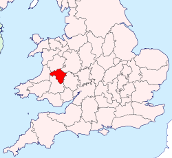
Until 1974, Radnorshire (Welsh: Sir Faesyfed) was an administrative county in mid Wales, later classed as one of the thirteen historic counties of Wales. It covered a sparsely populated area, and was bounded to the north by Montgomeryshire and Shropshire, to the east by Herefordshire, to the south by Brecknockshire and to the west by Cardiganshire.
The county was formed in 1536[a] from several Marcher lordships under the Laws in Wales Acts, as part of the formal annexation of Wales into the Kingdom of England by Henry VIII. The county was named after New Radnor, which was the original county town. From 1543 onwards the assizes were held alternately at New Radnor and Presteigne, later settling at Presteigne alone. Presteigne then served as the county's administrative centre until 1889 when Radnorshire County Council was established and chose to base itself in Llandrindod Wells instead.
The administrative county was abolished in 1974, with the area becoming the lower-tier Radnor district within the new county of Powys. The district was renamed Radnorshire in 1989. Radnorshire District Council was abolished in 1996 when Powys became a unitary authority. Powys County Council then had a Radnorshire "shire committee" until 2018.
The largest town in Radnorshire was Llandrindod Wells, with other towns being Knighton, Presteigne, and Rhayader. The Radnor Forest is an area of high ground covering a large part of the east of former county.
- ^ Vision of Britain - 1831 Census
Cite error: There are <ref group=lower-alpha> tags or {{efn}} templates on this page, but the references will not show without a {{reflist|group=lower-alpha}} template or {{notelist}} template (see the help page).


