| Rainbow Springs State Park | |
|---|---|
IUCN category V (protected landscape/seascape) | |
 Rainbow Springs | |
| Location | Marion County, Florida, USA |
| Nearest city | Dunnellon |
| Coordinates | 29°6′9.57″N 82°26′13.38″W / 29.1026583°N 82.4370500°W |
| Area | 1,000 acres (4.0 km2) |
| Governing body | Florida Department of Environmental Protection |
| Designated | 1990 |


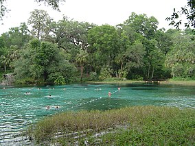
Rainbow Springs State Park is a Florida state park located on U.S. 41, 3 miles (5 km) north of Dunnellon, Florida. It comprises 1,459.07 acres (5.9046 km2) upland (which includes around 100 acres (0.40 km2) of wetlands) and 12.83 acres (51,900 m2) submerged. The most significant natural feature is the first-magnitude headspring basin, which produces up to 600,000,000 US gallons (2,300,000 m3) of fresh water per day, forming the Rainbow River. The looking-glass waters of Rainbow Springs come from several vents, not one large bubbling spring. The river itself supports a wide variety of fish, wildlife, and plants, many within easy viewing by visitors. In total, the park contains 11 distinct natural communities, including sandhills, flatwoods, upland mixed forests, and hydric hammocks.
Visitors are able to see a variety of wildflowers in season; oak, longleaf pines, magnolia, dogwood, red maple, redbud, cypress, sabal, and hickory trees; gray squirrels, red-shouldered hawks, swallowtail kites, barred owls, whitetail deer, and a wide variety of wading birds. The relative peace and quiet of the winter season offers much for the nature enthusiast. An interpretive room located in the visitor center displays the historical, natural, and cultural resources of the park.


