Back Ranfurly CEB Ranfurly (Seland Newydd) Welsh Ranfurly (Neuseeland) German Ranfurly (Nouvelle-Zélande) French Ranfurly, New Zealand Malay Ranfurly Polish رینفورلی، نیوزی لینڈ Urdu
Ranfurly | |
|---|---|
Settlement | |
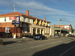
 The main street of Ranfurly | |
 | |
| Coordinates: 45°08′S 170°06′E / 45.133°S 170.100°E | |
| Country | New Zealand |
| Region | Otago |
| Territorial authority | Central Otago District |
| Ward | Maniototo Ward |
| Community | Maniototo Community |
| Electorates |
|
| Government | |
| • Territorial authority | Central Otago District Council |
| • Regional council | Otago Regional Council |
| • Mayor of Central Otago | Tamah Alley |
| • Waitaki MP | Miles Anderson |
| • Te Tai Tonga MP | Tākuta Ferris |
| Area | |
| • Urban area | 3.86 km2 (1.49 sq mi) |
| Population (June 2024)[2] | |
| • Urban area | 780 |
| • Density | 200/km2 (520/sq mi) |
| Time zone | UTC+12 (NZST) |
| • Summer (DST) | UTC+13 (NZDT) |
Ranfurly is a town in the Central Otago District of Otago, New Zealand. Located 110 kilometres (68 miles) north of Dunedin, it lies in the dry rough plain of Maniototo at a moderately high altitude (around 430 metres or 1,410 feet above sea level) close to a small tributary of the Taieri River. It operates as a service town for the local farming community. The town was formerly known as Eweburn, one of the "farmyard" names bestowed by former Otago Chief Surveyor John Turnbull Thomson on many small streams and locations in the district. The modern name honours the Fifth Earl of Ranfurly, who served as Governor of New Zealand (1897–1904) at the time of the extension of the Otago Central Railway to the area. Ranfurly is well known for its Art Deco buildings, such as its hotel and the dairy.
- ^ Cite error: The named reference
Areawas invoked but never defined (see the help page). - ^ "Aotearoa Data Explorer". Statistics New Zealand. Retrieved 26 October 2024.