Back Rathkeale Catalan Rathkeale CEB Rathkeale German Rathkeale Spanish Rathkeale Basque Ráth Caola Irish Rathkeale Italian Rathkeale Polish Раткил Russian Rathkeale Swedish
This article needs additional citations for verification. (November 2010) |
Rathkeale
Ráth Caola | |
|---|---|
Town | |
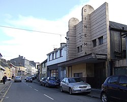
 Rathkeale main street, with former Central Cinema | |
| Coordinates: 52°31′00″N 8°56′00″W / 52.516667°N 8.933333°W | |
| Country | Ireland |
| Province | Munster |
| County | County Limerick |
| Elevation | 45 m (148 ft) |
| Population | 1,441 |
| Irish Grid Reference | R360420 |
Rathkeale (Irish: Ráth Caola, meaning 'Caola's ringfort'[2][3]) is a town in west County Limerick, in Ireland. It is 30 km (18 mi) southwest of Limerick city on the N21 road to Tralee, County Kerry, and lies on the River Deel. The town is in a townland and civil parish of the same name.[3]
It has a significant Irish Traveller population, and since 1995, almost half the town residents were members of the travelling community.[4] Rathkeale also has the largest concentration of descendants of the German Palatines who immigrated to Ireland in the early 18th century.
Rathkeale has shopping facilities, a museum, two primary schools, and a community college (Coláiste na Trócaire, founded in 1995). The town has a large Roman Catholic parish church, St. Mary's,[5][6] Augustinian Abbey ruins, and the Holy Trinity Church of Ireland church.
- ^ "Census 2016 - Small Area Population Statistics (SAPMAP Area) - Settlements - Rathkeale". Census 2016. Central Statistics Office.
- ^ "Rathkeale History & Heritage | Limerick.ie". limerick.ie. Retrieved 25 November 2020.
- ^ a b "Ráth Caola/Rathkeale". logainm.ie. Retrieved 8 March 2023.
- ^ "Rathkeale A Unique Town". RTÉ Archives. Retrieved 25 November 2020.
- ^ "Rathkeale". www.limerickdiocese.org. Retrieved 16 January 2024.
- ^ "St Mary Church – Rathkeale". Retrieved 16 January 2024.
