Back نهر ريد سيدار ARZ Red Cedar River (suba sa Tinipong Bansa, Michigan) CEB Red Cedar (rijeka) Serbo-Croatian
| Red Cedar River | |
|---|---|
 The Red Cedar River on the campus of Michigan State University in autumn | |
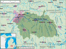
 A map of the Red Cedar River and its watershed | |
| Location | |
| Country | United States |
| State | Michigan |
| Counties | Ingham, Livingston |
| Cities | Fowlerville, Williamston, Okemos, East Lansing, Lansing |
| Physical characteristics | |
| Source | Cedar Lake |
| • location | Livingston County, Michigan, United States |
| • coordinates | 42°31′03″N 83°58′42″W / 42.51750°N 83.97833°W |
| Mouth | Grand River |
• location | Lansing, Michigan, United States |
• coordinates | 42°43′29″N 84°32′53″W / 42.72472°N 84.54806°W |
| Length | 51 mi (82 km) |
| Basin size | 461 sq mi (1,190 km2) |
| Discharge | |
| • location | mouth |
| • average | 332.88 cu ft/s (9.426 m3/s) (estimate)[1] |


The Red Cedar River is a 51.1-mile-long (82.2 km) river in the U.S. state of Michigan. The river, which is a tributary of the Grand River in Michigan's Lower Peninsula, drains a watershed of approximately 461 square miles (1,190 km2) in the Lansing–East Lansing metropolitan area and suburban and rural areas to the east. The river flows through the campus of Michigan State University, and is considered a cultural symbol of the school, including being mentioned in the school's fight song.
- ^ United States Environmental Protection Agency. "Watershed Report: Red Cedar River". watersgeo.epa.gov. Archived from the original on 2021-06-29. Retrieved 2021-06-29.