37°47′51″N 122°11′18″W / 37.79750°N 122.18833°W
This article has multiple issues. Please help improve it or discuss these issues on the talk page. (Learn how and when to remove these template messages)
|
Redwood Heights | |
|---|---|
 A sign welcoming motorists to Redwood Heights | |
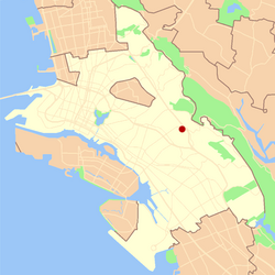
 Location of Redwood Heights in Oakland | |
| Coordinates: 37°47′51″N 122°11′18″W / 37.7975°N 122.188333°W | |
| Country | United States |
| State | California |
| County | Alameda |
| City | Oakland |
Redwood Heights is a primarily middle-class and highly diverse residential neighborhood in the hills of East Oakland, California. It is centered on Redwood Road, which was once a logging road. Redwood Road is the designation for 35th Avenue, starting about one mile north of MacArthur Boulevard between Victor Avenue and the Warren Freeway (California State Route 13). It lies at an elevation of 476 feet (145 m).
Redwood Heights Elementary School and the recreation center serve as the heart of the community. The recreation center also serves as an after-school daycare for the school and nearby area. Another feature of the neighborhood is Avenue Terrace Park, also known as Jordan Park, located at Jordan Road and Bennett Place.
The homes in Redwood Heights primarily originated between the 1920s and 1950s, showcasing a wide range of architectural styles. These styles include craftsman, "storybook," and ranch designs.
Redwood Heights has one of Oakland's most ethnically diverse neighborhoods with a primarily middle-class population. The 2010 Census reflects the primary zip code (94619) for the neighborhood as having about 23,200 residents, with Caucasians making up about 29.9% of the population, African Americans 26.2%, Asians 22%, and Latinos 16.1%, with other races forming the remaining 5.8%.
