Back Queens County (kondado sa Kanada, Nova Scotia) CEB Region of Queens Municipality German Queens (Nouvelle-Écosse) French クイーンズ地域 (ノバスコシア州) Japanese Queens (regional municipality) Polish Queens (Nova Escócia) Portuguese Region of Queens Municipality SIMPLE Queens County (county i Kanada, Nova Scotia) Swedish Квінс (Нова Шотландія) Ukrainian
Region of Queens Municipality | |
|---|---|
| Motto(s): Rivers, Forest, Sea | |
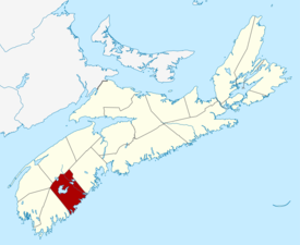
 Location of Region of Queens Municipality, Nova Scotia | |
| Coordinates: 44°02′N 64°43′W / 44.033°N 64.717°W | |
| Country | Canada |
| Province | Nova Scotia |
| Incorporated | April 1, 1996 |
| Electoral Districts Federal | South Shore—St. Margaret's |
| Provincial | Queens-Shelburne |
| Government | |
| • Type | Queens Regional Council |
| • Mayor | Darlene Norman |
| Area (2016)[1] | |
| • Land | 2,387.52 km2 (921.83 sq mi) |
| Population (2021)[1] | |
| • Total | 10,422 |
| • Density | 4.3/km2 (11/sq mi) |
| • Change 2011-2016 | |
| • Census ranking | 400 of 5,162 |
| Time zone | UTC-4 (AST) |
| • Summer (DST) | UTC-3 (ADT) |
| Area code(s) | 902, 782 |
| Dwellings | 6,150 |
| Median Income* | $36,461 CDN |
| Website | regionofqueens.com |
| |
The Region of Queens Municipality is a regional municipality in southwestern Nova Scotia, Canada. It is the northern gateway of the UNESCO Southwest Nova Biosphere Reserve, a centre of outdoor activities. Campgrounds at Kejimukujik National Park and National Historic Site, Thomas H. Raddall Provincial Park, and several other locations offer hiking, biking, canoeing, kayaking, cross-country skiing and snowshoeing. Its seacoast and inland areas are popular photo locations.
- ^ a b "Population and dwelling counts, for Canada, provinces and territories, and census subdivisions (municipalities), 2016 and 2011 censuses – 100% data (Nova Scotia)". Statistics Canada. February 8, 2017. Retrieved February 12, 2017.
