| Rio Puerco | |
|---|---|
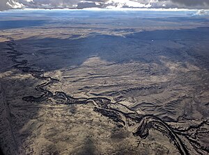
 The Rio Puerco where it crosses the eastern edge of the Tohajiilee Indian Reservation, just west of Albuquerque's West Mesa, Petroglyph National Monument, and Double Eagle II Airport | |
 Map of the Rio Grande watershed, showing the Rio Puerco joining the Rio Grande near Albuquerque. | |
| Location | |
| Country | United States |
| State | New Mexico |
| County | Socorro, Valencia, Bernalillo, Sandoval, Rio Arriba |
| Physical characteristics | |
| Source | San Pedro Peaks |
| • location | Nacimiento Mountains |
| • coordinates | 36°7′28″N 106°49′53″W / 36.12444°N 106.83139°W[1] |
| • elevation | 10,500 ft (3,200 m)[2] |
| Mouth | Rio Grande |
• coordinates | 34°22′23″N 106°50′33″W / 34.37306°N 106.84250°W[1] |
• elevation | 4,711 ft (1,436 m)[1] |
| Length | 230 mi (370 km)[3] |
| Basin size | 7,350 sq mi (19,000 km2)[4] |
| Discharge | |
| • location | USGS gage 08353000, 3 miles above mouth[4] |
| • average | 39.5 cu ft/s (1.12 m3/s)[4] |
| • minimum | 0 cu ft/s (0 m3/s) |
| • maximum | 35,000 cu ft/s (990 m3/s) |

The Rio Puerco is a tributary of the Rio Grande in the U.S. state of New Mexico. From its source on the west side of the Nacimiento Mountains, it flows about 230 miles (370 km),[3] generally south to join the Rio Grande about 20 miles (32 km) south of Belen and about 50 miles (80 km) south of Albuquerque. Its drainage basin is about 7,350 square miles (19,000 km2) large, of which probably about 1,130 square miles (2,900 km2) are noncontributing.[4]
The Rio Puerco is ephemeral, with no streamflow for part of the year. Its discharge averages 39.5 cubic feet per second (1.12 m3/s). The maximum officially recorded discharge was 5,980 cubic feet per second (169 m3/s), in 1941. The greatest flood since about 1880 occurred on September 23, 1929, with an estimated discharge of 35,000 cubic feet per second (990 m3/s). Another flood, on August 12, 1929, reached an estimated 30,600 cubic feet per second (870 m3/s).[4]
- ^ a b c U.S. Geological Survey Geographic Names Information System: Rio Puerco
- ^ Cite error: The named reference
topowas invoked but never defined (see the help page). - ^ a b Calculated in Google Earth
- ^ a b c d e "Water resources data for the United States, Water Year 2009; gage 08353000, Rio Puerco near Barnardo, NM" (PDF). USGS. Retrieved 21 July 2010.
