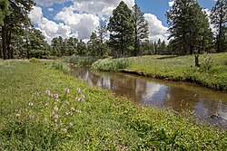
| Rio de Flag | |
|---|---|
 | |
| Physical characteristics | |
| Source | Leroux Springs |
| • location | San Francisco Peaks, Arizona |
| • coordinates | 35°17′36″N 111°43′30″W / 35.29333°N 111.72500°W |
| • elevation | 8,000 feet (2,400 m) |
| Mouth | San Francisco Wash |
• location | Walnut Creek, Arizona |
• coordinates | 35°14′12″N 111°10′43″W / 35.23667°N 111.17861°W |
• elevation | 7,000 feet (2,100 m) |
| Length | 33 miles (53 km)[1] |
| Basin features | |
| Tributaries | |
| • left | Schultz Creek |
| • right | Sinclair Wash |
| Waterbodies | Frances Short Pond, Logan's Crossing |
| Waterfalls | Picture Canyon |
The Rio de Flag, which has historically been known as the River de Flag[2] and San Francisco river,[3] is a river in Arizona that runs through Flagstaff, originating from the San Francisco Peaks before draining into the Little Colorado River. The river's age is unknown, though its first channels were around over one million years ago.[4]
- ^ "Resources". Friends of the Rio de Flag. Retrieved 2020-04-13. See document "FOR Rio de Flag Main Stem Channel Length Data – by Collis Lovely"
- ^ Olberding, Susan Deaver (2002). Fort Valley Then and Now (PDF). Fort Valley Pub. p. 6. ISBN 978-09720048-0-0.
- ^ Whipple, A. W. (1855). Report of Explorations for a Railway Route, Near the Thirty-fifth Parallel of Latitude, for the Mississippi River to the Pacific Ocean (PDF). p. 23.
- ^ "New Publication explores the origin and geology of the Rio de Flag of Flagstaff, Arizona | e-Magazine of the AZ Geological Survey". blog.azgs.arizona.edu. Retrieved 2020-04-07.
