Back مقاطعة ريتشي (فرجينيا الغربية) Arabic Ritchie County, West Virginia BAR Ричи (окръг, Западна Вирджиния) Bulgarian রিটচি কাউন্টি, ৱেস্ট ভার্জিনিয়া BPY Ritchie Gông (West Virginia) CDO Ритчи (гуо, Малхбузен Виргини) CE Ritchie County CEB Ritchie County, Gorllewin Virginia Welsh Ritchie County German Kantono Ritchie Esperanto
Ritchie County | |
|---|---|
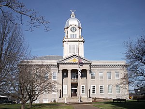
 Ritchie County Courthouse in Harrisville | |
 Location within the U.S. state of West Virginia | |
 West Virginia's location within the U.S. | |
| Coordinates: 39°11′N 81°04′W / 39.18°N 81.07°W | |
| Country | |
| State | |
| Founded | February 18, 1843 |
| Named for | Thomas Ritchie |
| Seat | Harrisville |
| Largest town | Harrisville |
| Area | |
| • Total | 454 sq mi (1,180 km2) |
| • Land | 452 sq mi (1,170 km2) |
| • Water | 1.7 sq mi (4 km2) 0.4% |
| Population (2020) | |
| • Total | 8,444 |
| • Estimate (2021) | 8,383 |
| • Density | 19/sq mi (7.2/km2) |
| Time zone | UTC−5 (Eastern) |
| • Summer (DST) | UTC−4 (EDT) |
| Congressional district | 1st |
| Website | www |
Ritchie County is a county in the U.S. state of West Virginia. As of the 2020 census, the population was 8,444.[1] Its county seat is Harrisville.[2] The county was created in 1843 by the Virginia General Assembly and named for Richmond newspaper publisher Thomas Ritchie.[3]
- ^ "State & County QuickFacts". United States Census Bureau. Retrieved October 20, 2022.
- ^ "Find a County". National Association of Counties. Retrieved June 7, 2011.
- ^ "Ritchie County history sources". Archived from the original on May 29, 2013. Retrieved January 29, 2013.