Back نهر ارون ARZ River Arun CEB River Arun German رود آرون Persian Arun (joki) Finnish Arun (rivière) French Sungai Arun ID Arun (rivier in Engeland) Dutch Arun-elva NN Arun (elv) NB
| Arun Tarrant | |
|---|---|
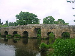
 Stopham Bridge near Pulborough. The centre arch was raised in 1822. | |
 Course of the Arun | |
| Location | |
| Country | England |
| County | West Sussex |
| Towns | Horsham, Arundel, Littlehampton |
| Physical characteristics | |
| Source | |
| • location | St Leonard's Forest, West Sussex |
| • elevation | 125 m (410 ft) |
| Mouth | |
• location | Littlehampton, West Sussex |
• elevation | 0 m (0 ft) |
| Length | 60 km (37 mi) |
| Basin size | 376 sq mi (970 km2) |
| Discharge | |
| • location | Pallingham Quay |
| • average | 4.78 m3/s (169 cu ft/s) |
| • minimum | 0.31 m3/s (11 cu ft/s) |
| • maximum | 78.5 m3/s (2,770 cu ft/s) |
| Discharge | |
| • location | Alfoldean |
| • average | 1.84 m3/s (65 cu ft/s) |
| Basin features | |
| Tributaries | |
| • left | River Stor, River Kird, North River, River Lox / Loxwood Stream |
| • right | River Rother |
| Protection status | |
| Official name | Arun Valley |
| Designated | 16 December 1999 |
| Reference no. | 1011[1] |
River Arun | ||||||||||||||||||||||||||||||||||||||||||||||||||||||||||||||||||||||||||||||||||||||||||||||||||||||||||||||||||||||||||||||||||||||||||||||||||||||||||||||||||||||||||||||||||||||||||||||||||||||||||||||||||||||||||||||||||||||||||||||||||||||||||||||||||||||||||||||||||||||||||||||||||||||||||||||||||||||||||||||||||||||||||||||||
|---|---|---|---|---|---|---|---|---|---|---|---|---|---|---|---|---|---|---|---|---|---|---|---|---|---|---|---|---|---|---|---|---|---|---|---|---|---|---|---|---|---|---|---|---|---|---|---|---|---|---|---|---|---|---|---|---|---|---|---|---|---|---|---|---|---|---|---|---|---|---|---|---|---|---|---|---|---|---|---|---|---|---|---|---|---|---|---|---|---|---|---|---|---|---|---|---|---|---|---|---|---|---|---|---|---|---|---|---|---|---|---|---|---|---|---|---|---|---|---|---|---|---|---|---|---|---|---|---|---|---|---|---|---|---|---|---|---|---|---|---|---|---|---|---|---|---|---|---|---|---|---|---|---|---|---|---|---|---|---|---|---|---|---|---|---|---|---|---|---|---|---|---|---|---|---|---|---|---|---|---|---|---|---|---|---|---|---|---|---|---|---|---|---|---|---|---|---|---|---|---|---|---|---|---|---|---|---|---|---|---|---|---|---|---|---|---|---|---|---|---|---|---|---|---|---|---|---|---|---|---|---|---|---|---|---|---|---|---|---|---|---|---|---|---|---|---|---|---|---|---|---|---|---|---|---|---|---|---|---|---|---|---|---|---|---|---|---|---|---|---|---|---|---|---|---|---|---|---|---|---|---|---|---|---|---|---|---|---|---|---|---|---|---|---|---|---|---|---|---|---|---|---|---|---|---|---|---|---|---|---|---|---|---|---|---|---|---|---|---|---|---|---|---|---|---|---|---|---|---|---|---|---|---|---|---|---|
| ||||||||||||||||||||||||||||||||||||||||||||||||||||||||||||||||||||||||||||||||||||||||||||||||||||||||||||||||||||||||||||||||||||||||||||||||||||||||||||||||||||||||||||||||||||||||||||||||||||||||||||||||||||||||||||||||||||||||||||||||||||||||||||||||||||||||||||||||||||||||||||||||||||||||||||||||||||||||||||||||||||||||||||||||
The River Arun (/ˈærən/) is a river in the English county of West Sussex. At 37 miles (60 km) long, it is the longest river entirely in Sussex[2] and one of the longest starting in Sussex after the River Medway, River Wey and River Mole. From the series of small streams that form its source in the area of St Leonard's Forest in the Weald, the Arun flows westwards through Horsham to Nowhurst where it is joined by the North River. Turning to the south, it is joined by its main tributary, the western River Rother, and continues through a gap in the South Downs to Arundel to join the English Channel at Littlehampton. It is one of the faster flowing rivers in England, and is tidal as far inland as Pallingham Quay, 25.5 miles (41.0 km) upstream from the sea at Littlehampton. The Arun gives its name to the Arun local government district of West Sussex.
The first major improvements to the river were made between the 1540s and the 1570s, when Arundel became a port, and navigation up to Pallingham was improved, but barges had difficulty negotiating the flash locks that were installed. The work was carried out by Henry FitzAlan, 19th Earl of Arundel, who made the upper section toll-free. Harbour commissioners managed the lower river from Arundel to the sea from 1732, and major improvements to keep the estuary free from silt were sanctioned by an act of Parliament[which?] obtained in 1793. With the coming of the railways and changes in coastal shipping, Littlehampton superseded Arundel as the port of the Arun, and the Littlehampton harbour commissioners are still responsible for the river up to Arundel, collecting tolls for its use.
The river above Arundel was improved after 1785. As the main channel was toll-free, the proprietors of the scheme built two major cuts. One, which included three locks and passed through Hardham Tunnel, was built to avoid a large bend near Pulborough. The other was near the upper terminus, where a cut with three locks and a flood lock crossed the original channel by an aqueduct to reach wharves at Newbridge. Further improvements were made when the Wey and Arun Canal opened in 1816, joining the Arun Navigation at Newbridge, and after the completion of the Portsmouth and Arundel Canal, which opened soon afterwards. These two canals were an attempt to provide an inland route between London and Portsmouth, but were not as successful as the proprietors hoped. Traffic declined rapidly when the railways offered competition, and the navigation ceased to be maintained from 1888, though some traffic continued on the lower sections. The Wey and Arun Canal is currently being restored, and restoration will eventually include the cut and locks below Newbridge.