Back River Dearne CEB Dearne French Dearne Polish Dearne (rijeka) Serbo-Croatian River Dearne Swedish
| River Dearne | |
|---|---|
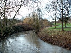
 The River Dearne viewed from the bridge behind Darton Post Office. | |
 | |
| Location | |
| Country | England |
| Physical characteristics | |
| Source | |
| • location | Birdsedge nr Denby Dale |
| • coordinates | 53°33′52″N 1°42′37″W / 53.56444°N 1.71028°W |
| • elevation | 328 metres (1,076 ft) |
| Mouth | |
• location | River Don near Conisbrough |
• coordinates | 53°29′39″N 1°14′34″W / 53.49417°N 1.24278°W |
• elevation | 17 metres (56 ft) |
| Length | 51.9 kilometres (32.2 mi) |
| Basin size | 310.8 square kilometres (120.0 sq mi) |
River Dearne | ||||||||||||||||||||||||||||||||||||||||||||||||||||||||||||||||||||||||||||||||||||||||||||||||||||||||||||||||||||||||||||||||||||||||||||||||||||||||||||||||||||||||||||||||||||||||||||||||||||||||||||||||||||||||||||||||||||||||||||||
|---|---|---|---|---|---|---|---|---|---|---|---|---|---|---|---|---|---|---|---|---|---|---|---|---|---|---|---|---|---|---|---|---|---|---|---|---|---|---|---|---|---|---|---|---|---|---|---|---|---|---|---|---|---|---|---|---|---|---|---|---|---|---|---|---|---|---|---|---|---|---|---|---|---|---|---|---|---|---|---|---|---|---|---|---|---|---|---|---|---|---|---|---|---|---|---|---|---|---|---|---|---|---|---|---|---|---|---|---|---|---|---|---|---|---|---|---|---|---|---|---|---|---|---|---|---|---|---|---|---|---|---|---|---|---|---|---|---|---|---|---|---|---|---|---|---|---|---|---|---|---|---|---|---|---|---|---|---|---|---|---|---|---|---|---|---|---|---|---|---|---|---|---|---|---|---|---|---|---|---|---|---|---|---|---|---|---|---|---|---|---|---|---|---|---|---|---|---|---|---|---|---|---|---|---|---|---|---|---|---|---|---|---|---|---|---|---|---|---|---|---|---|---|---|---|---|---|---|---|---|---|---|---|---|---|---|---|---|---|
| ||||||||||||||||||||||||||||||||||||||||||||||||||||||||||||||||||||||||||||||||||||||||||||||||||||||||||||||||||||||||||||||||||||||||||||||||||||||||||||||||||||||||||||||||||||||||||||||||||||||||||||||||||||||||||||||||||||||||||||||
The River Dearne South Yorkshire, England flows roughly east for more than 30 kilometres (19 mi), from its source just inside West Yorkshire. It flows through Denby Dale, Clayton West, Darton, Barnsley, Darfield, Wath upon Dearne, Bolton on Dearne, Adwick upon Dearne and Mexborough to its confluence with the River Don at Denaby Main. Its main tributary is the River Dove, which joins it at Darfield. The river was one of those affected by the 2007 United Kingdom floods.
The course of the river is accessible to walkers as the Dearne Way, a long distance footpath from Dearne Head to the river's junction with the Don. Places of interest along the Dearne include the Yorkshire Sculpture Park at West Bretton, and Monk Bretton Priory. The Dearne Valley below Barnsley is a regeneration area.
The river has been subject to channel engineering to ease the problem of flooding. A new channel was constructed near its mouth in the 1950s, as the old route had been affected by mining subsidence. Washlands, which can be progressively flooded as water levels rise, were constructed in the 1960s and 1970s. A flood relief channel and a regulator to restrict the flow was built at Bolton upon Dearne. During the 2007 United Kingdom floods, the washlands filled to capacity but the regulator could not be operated as it had been vandalised.
Industrialisation caused the river and the Dearne and Dove Canal, to become grossly polluted in the early nineteenth century and fish populations died. The West Riding River Board tried to address the problems in 1896 with limited success and much of the river remained dead until the 1980s, when industrial effluents were removed before they were discharged and improvements were made to sewage treatment. Despite setbacks, fish populations had been partially reinstated by the early 1990s. Channel engineering was carried out at Denaby in the 1990s, to re-introduce bends, deep pools and shallow gravel riffles, to assist fish spawning. In June 2015, salmon were reported in the river for the first time in 150 years.