Back نهر دون (نهر) ARZ River Don (suba sa Hiniusang Gingharian, Inglatera, lat 53,68, long -0,85) CEB Afon Don (Swydd Efrog) Welsh Don (flod i England) Danish River Don (Ouse) German Río Don (Inglaterra) Spanish Don (Yorkshire) French Don (fiume Yorkshire) Italian Dona (Ūzas pieteka) Latvian/Lettish Don i South Yorkshire NN
| River Don | |
|---|---|
 A footbridge, looking towards Newton | |
 | |
| Location | |
| Country | England |
| Physical characteristics | |
| Source | |
| • location | Pennines |
| • coordinates | 53°31′08″N 1°45′43″W / 53.519°N 1.762°W |
| Mouth | |
• location | River Trent/River Ouse |
• coordinates | 53°41′49″N 0°52′01″W / 53.697°N 0.867°W |
| Length | 69 mi (111 km) |
 | |
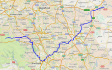
The River Don (also called River Dun in some stretches) is a river in South Yorkshire and the East Riding of Yorkshire, England. It rises in the Pennines, west of Dunford Bridge, and flows for 69 miles (111 km) eastwards, through the Don Valley, via Penistone, Sheffield, Rotherham, Mexborough, Conisbrough, Doncaster and Stainforth. It originally joined the Trent, but was re-engineered by Cornelius Vermuyden as the Dutch River in the 1620s, and now joins the River Ouse at Goole. Don Valley is a UK parliamentary constituency near the Doncaster stretch of the river.