Back Rivierenbuurt German Rivierenbuurt (Amsterdam) French Rivierenbuurt (Amsterdam) ID Rivierenbuurt (Amsterdam) Dutch
Rivierenbuurt | |
|---|---|
Neighbourhood of Amsterdam | |
 Amsterdam School architecture, Holendrechtstraat, Rivierenbuurt, designed by Margaret Staal-Kropholler (1923). | |
 | |
| Country | Netherlands |
| Province | North Holland |
| COROP | Amsterdam |
| Borough | Zuid |
| Time zone | UTC+1 (CET) |
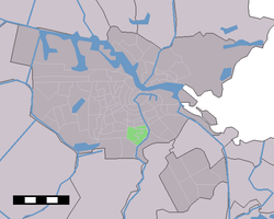
Rivierenbuurt is a neighbourhood of Amsterdam, Netherlands. The neighbourhood is situated in the eastern part of the borough of Amsterdam-Zuid, bordered by the river Amstel to the east, the Boerenwetering canal in the west, the Amstelkanaal in the north and the A10 motorway in the south. In 2013, the Rivierenbuurt had approximately 28,400 residents.[1]
The Rivierenbuurt was built in the 1920s as a primarily middle-class residential area, part of the Plan Zuid urban expansion programme designed by Dutch architect Hendrik Petrus Berlage.[2] The neighbourhood features many fine examples of Amsterdam School architecture. The Dutch word Rivierenbuurt translates as 'Rivers Neighbourhood'; most streets in the area are named after rivers in the Netherlands.
Until World War II the area had a sizable Jewish population[3] which included Anne Frank and her family, who lived at Merwedeplein square until they went into hiding in the secret annex located in the old city centre.[4]
The neighbourhood is served by tram routes 4 and 12, bus routes 62 and 65, as well as Amsterdam metro and national rail services from Amstel Station and Zuid Station.
- ^ "Over de buurt" (in Dutch). Borough of Amsterdam-Zuid, City of Amsterdam. 2014-04-09. Archived from the original on 2014-12-20. Retrieved 2014-08-06.
- ^ "Plan Zuid (1917)". www.artzuid.nl. Retrieved 20 July 2014.
- ^ Edeler, Dennis (2009). De drinkwaterfluoridering. Bohn Stafleu van Loghum. p. 27. ISBN 9789031352357.
- ^ Müller, Melissa (2013). Anne Frank: The Biography. Henry Holt and Company. p. 53. ISBN 9780805087314.