Back Robinvale CEB رابینویل Persian Robinvale French Robinvale Dutch Robinvale Polish Robinvale Swedish رابن ویل، وکٹوریہ Urdu
| Robinvale Victoria | |||||||||||||||
|---|---|---|---|---|---|---|---|---|---|---|---|---|---|---|---|
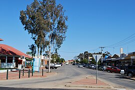
 Perrin Street, the main street of the town | |||||||||||||||
 | |||||||||||||||
| Coordinates | 34°35′S 142°46′E / 34.583°S 142.767°E | ||||||||||||||
| Population | 3,740 (2021 census)[1] | ||||||||||||||
| • Density | 53.35/km2 (138.18/sq mi) | ||||||||||||||
| Postcode(s) | 3549 | ||||||||||||||
| Elevation | 61 m (200 ft) | ||||||||||||||
| Area | 70.1 km2 (27.1 sq mi) | ||||||||||||||
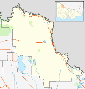
| Location | |||||||||||||||
| LGA(s) | Rural City of Swan Hill | ||||||||||||||
| State electorate(s) | Mildura | ||||||||||||||
| Federal division(s) | Mallee | ||||||||||||||
| |||||||||||||||
| |||||||||||||||
Robinvale is a town on the south bank of the Murray River in north western Victoria, Australia. It is connected by a bridge to Euston on the other side of the river in New South Wales. At the 2021 census, Robinvale had a population of 3,740,[1] however a population study conducted by the Rural City of Swan Hill that was undertaken in 2019 identified Robinvale had an estimated population of between 7,000 in November and 8,800 in March each year.[2]
- ^ a b "2021 Census QuickStats Robinvale". Australian Bureau of Statistics. Retrieved 15 November 2023.
- ^ "Robinvale housing and population". Swan Hill Rural City Council. Retrieved 23 February 2021.
