Back روزبود، گونئی داکوتا AZB Rosebud (Dakota del Sud) Catalan Роузбад (Къилба Дакота) CE Sicanġu (lungsod sa Tinipong Bansa, South Dakota) CEB Rosebud (South Dakota) German Rosebud (Dakota del Sur) Spanish Rosebud (Hego Dakota) Basque رووزباد، داکوتای جنوبی Persian Rosebud (Súd-Dakota) Frisian Rosebud (Dakota del Sud) Italian
Rosebud, South Dakota
Sicanġu | |
|---|---|
CDP | |
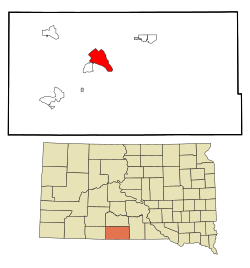
 Location in Todd County and the state of South Dakota | |
| Coordinates: 43°14′24″N 100°49′23″W / 43.24000°N 100.82306°W | |
| Country | United States |
| State | South Dakota |
| Counties | Todd |
| Area | |
| • Total | 13.1 sq mi (34 km2) |
| • Land | 13.1 sq mi (33.9 km2) |
| • Water | 0 sq mi (0.1 km2) |
| Elevation | 2,838 ft (865 m) |
| Population (2020) | |
| • Total | 1,455 |
| • Density | 121.1/sq mi (46.8/km2) |
| GNIS feature ID | 2393213[1] |
Rosebud also Sicanġu (Lakhota Sicanġu;[2] "Scorched Thigh") is a census-designated place (CDP) in Todd County, South Dakota, United States. The population was 1,455 at the 2020 census.[3]
Rosebud is located on the Rosebud Indian Reservation. It is home to the Rosebud Sioux tribe. Rosebud also has many tribal agencies such as the Indian Health Service, Bureau of Indian Affairs, Tribal Land Enterprise, Tribal BIA Police, and the Division of Forestry and Wildland Fire Management.
- ^ a b U.S. Geological Survey Geographic Names Information System: Rosebud, South Dakota
- ^ Ullrich, Jan F. (2014). New Lakota Dictionary (2nd ed.). Bloomington, IN: Lakota Language Consortium. ISBN 978-0-9761082-9-0.
- ^ "U.S. Census Bureau: Rosebud CDP, South Dakota". www.census.gov. United States Census Bureau. Retrieved December 22, 2021.