This article needs additional citations for verification. (May 2010) |
50°10′N 5°00′W / 50.167°N 5.000°W


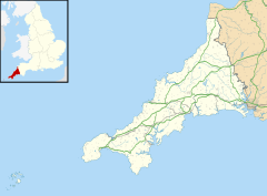
The Roseland Peninsula, or just Roseland, (Cornish: Ros, meaning promontory) is a district of west Cornwall, England. Roseland is located in the south of the county and contains the town of St Mawes and villages such as St Just and Gerrans. It is a peninsula, separated from the remainder of Cornwall by the River Fal (on the east is the English Channel).
Where the peninsula begins continues to be a point of discussion amongst local historians and long-time Roseland inhabitants. The village of Tregony might be considered to be outside the Roseland. If travelling by road one enters the Roseland at the bottom of Tregony Hill by either driving up Reskivers Hill to take the road to St. Mawes and Gerrans, or by taking the lower road to Ruan Lanihorne. The Roseland Plan, a neighbourhood plan produced in 2015, defined Roseland as the areas of the civil parishes of St-Just-in-Roseland (which includes St Mawes), Gerrans, Philleigh, Ruanlanihorne and Veryan.[1]
One of Britain's most infamous unsolved murders was committed on the peninsula in 1998. 41-year-old Lyn Bryant was randomly and repeatedly stabbed while walking her dog in Ruan High Lanes on 20 October 1998. Her attacker has never been identified despite one of the longest-running and largest ever investigations by Devon and Cornwall Police, although the killer's DNA was isolated in 2018. There remains a £10,000 reward for information leading to the capture of her killer.
Until 2021 there was a Roseland electoral division of Cornwall Council which also covered St Mawes, the population of which at the 2011 census was 3,375.[2]
- ^ "The Roseland Plan". Retrieved 17 February 2024.
- ^ "Ward population 2011". Retrieved 12 February 2015.

