Back Rothesay (lungsod sa Kanada) CEB Rothesay (New Brunswick) German Rothesay (New Brunswick) Estonian رات اسی، نیوبرانزویک Persian Rothesay (Nouveau-Brunswick) French Rothesay (Nuovo Brunswick) Italian ローゼイ (カナダ) Japanese Rothesay (Canada) Dutch Rothesay (Nowy Brunszwik) Polish Rothesay, Kanada Swedish
Rothesay | |
|---|---|
Town | |
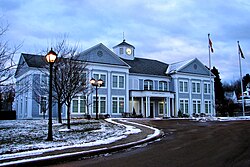
 Rothesay Town Hall | |
| Motto(s): | |
| Coordinates: 45°22′59″N 65°59′49″W / 45.38306°N 65.99694°W | |
| Country | Canada |
| Province | New Brunswick |
| County | Kings County |
| Founded | August 4, 1860 |
| Amalgamation | January 1, 1998 |
| Electoral Districts Federal | Saint John—Rothesay |
| Provincial | Rothesay |
| Government | |
| • Type | Town Council |
| • Mayor | Dr. Nancy Grant |
| • MPs | Wayne Long |
| • MLAs | Ted Flemming |
| Area | |
| • Land | 34.59 km2 (13.36 sq mi) |
| Elevation | Sea level to 75 m (0 to 246 ft) |
| Population (2021)[1] | |
| • Total | 11,977 |
| • Density | 346.2/km2 (897/sq mi) |
| • Change (2016–21) | |
| Time zone | UTC−04:00 (AST) |
| • Summer (DST) | UTC−03:00 (ADT) |
| Canadian postal code | |
| Area code | 506 |
| Telephone Exchange | 847, 848, 849, 216 |
| NTS Map | 21H5 Loch Lomond |
| GNBC Code | DACOY |
| Website | www.rothesay.ca |
Rothesay (/ˈrɒ(θ)seɪ/) is a suburban town located in Kings County, New Brunswick, Canada. Located within Saint John's metropolitan area, it borders the town of Quispamsis to form the Kennebecasis Valley and is located along the lower Kennebecasis River. As of 2021, the population of Rothesay was 11,977.
- ^ a b "Census Profile of Rothesay, Town (TV)". Statistics Canada. 6 December 2022. Retrieved 21 January 2023.


