You can help expand this article with text translated from the corresponding article in Hebrew. Click [show] for important translation instructions.
|
| Local Road 4370 | |
|---|---|
| Eastern Ring Road כביש הטבעת המזרחי | |
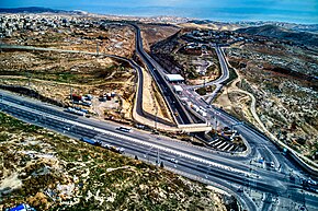
 Highway 1 - Route 4370 Junction (Al-Issawiya Junction) - one can see the barrier between the Israeli and the Palestinian lanes | |
| Route information | |
| Length | 3.7 km (2.3 mi) |
| Existed | 9 January 2019–present |
| Location | |
| Country | Israel |
| Major cities | Jerusalem |
| Highway system | |
Route 4370 or Eastern Ring Road, is a highway that connects the Geva Binyamin settlement in the Israeli-occupied West Bank and Jerusalem. It has been referred to by its critics as an "apartheid road" due to the fact that parts of it have separate traffic for Israeli plates and Palestinian plates.[1][2][3][4][5]
- ^ "Focus - The 'apartheid road': West Bank highway sparks controversy". France 24. February 4, 2019.
- ^ "New Jerusalem 'Apartheid Road' Opens, Separating Palestinians and Jewish Settlers" – via Haaretz.
- ^ "Protest closes Israel's 'apartheid road' through West Bank". the Guardian. January 23, 2019.
- ^ Giovannetti, Megan. "Israel opens 'apartheid road' in occupied West Bank". www.aljazeera.com. Retrieved 2021-12-17.
- ^ "Road opens with segregated lanes for Israelis, Palestinians". UPI.

