Alonsa | |
|---|---|
| Rural Municipality of Alonsa | |
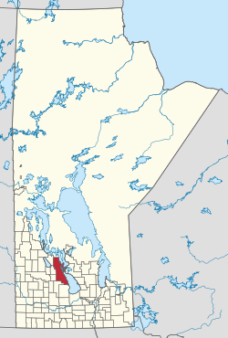
 Location of Alonsa in Manitoba | |
| Coordinates: 50°47′59″N 98°58′36″W / 50.7996°N 98.9766°W | |
| Country | Canada |
| Province | Manitoba |
| Region | Parkland |
| Incorporated as an LGD | January 1, 1945 |
| Incorporated as a rural municipality | January 1, 1997 |
| Government | |
| • Reeve | Tom Anderson[1] |
| • Councillors | Kerry Hopfner Tim Stott Travis Turko Michael Brown Terry Dayholos Logan Dumanske |
| Area | |
| • Total | 2,977.50 km2 (1,149.62 sq mi) |
| Population (2016)[2] | |
| • Total | 1,247 |
| Time zone | UTC-6 (CST) |
| • Summer (DST) | UTC-5 (CDT) |
| Website | rmofalonsa |
Alonsa is a rural municipality (RM) in the province of Manitoba, western Canada. It lies on the west side of Lake Manitoba.[2]
Located within the borders of the municipality is the Indian reserve of Ebb and Flow 52, as well as the 60,000 m2 (6 ha) Margaret Bruce Beach Provincial Park, located 12 km (7.5 mi) east of the town of Alonsa, on one of a series of sand ridges that extend the length of the west side lake. The park is currently under lease to a private operator but development plans include a provincial campground and day use facility.[3]
The incorporation of Alonsa on 1 January 1945 was as a Local Government District (LGD). It received rural municipality status on 1 January 1997.
- ^ "Members". April 22, 2017.
- ^ a b "Manitoba Communities: Alonsa (Rural Municipality)".
- ^ Margaret Bruce Recreation Parks, Planning Section 3, Gov of Manitoba Conservation
