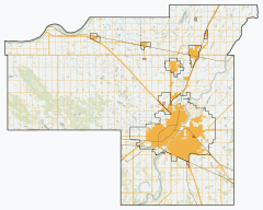
Corman Park No. 344 | |
|---|---|
| Rural Municipality of Corman Park No. 344 | |
 RM office and police station | |
 Location of the RM of Corman Park No. 344 in Saskatchewan | |
| Coordinates: 52°14′28″N 106°40′08″W / 52.241°N 106.669°W[1] | |
| Country | Canada |
| Province | Saskatchewan |
| Census division | 11 |
| SARM division | 5 |
| Federal riding | Carlton Trail—Eagle Creek Saskatoon—Grasswood |
| Provincial riding | Biggar-Sask Valley Martensville-Warman Rosetown-Elrose Saskatoon Stonebridge-Dakota |
| Formed[2] | January 1, 1970 |
| Amalgamated[3] | December 31, 1969 (RMs of Cory No. 344, Warman No. 374 and Park No. 375) |
| Government | |
| • Reeve | Judy Harwood |
| • Governing body | RM of Corman Park No. 344 Council |
| • Chief Administrative Officer | Ken Kolb |
| • Office location | Saskatoon |
| Area (2016)[5] | |
| • Land | 1,911.35 km2 (737.98 sq mi) |
| Population (2021)[5] | |
| • Total | 8,909 |
| • Density | 4.7/km2 (12/sq mi) |
| Time zone | CST |
| • Summer (DST) | CST |
| Postal code | S7K 5W1 |
| Area code(s) | 306 and 639 |
| Website | Official website |
The Rural Municipality of Corman Park No. 344 (2021 population: 8,909) is a rural municipality (RM) in the Canadian province of Saskatchewan within Census Division No. 11 and SARM Division No. 5. Located in the central portion of the province, the RM surrounds the City of Saskatoon.
- ^ "Pre-packaged CSV files - CGN, Canada/Province/Territory (cgn_sk_csv_eng.zip)". Government of Canada. July 24, 2019. Retrieved May 23, 2020.
- ^ Cite error: The named reference
ruralincorpwas invoked but never defined (see the help page). - ^ Cite error: The named reference
historywas invoked but never defined (see the help page). - ^ "Municipality Details: RM of Corman Park No. 344". Government of Saskatchewan. Retrieved May 21, 2020.
- ^ a b Cite error: The named reference
2016censusSKmuniswas invoked but never defined (see the help page).

