East St. Paul | |
|---|---|
| Rural Municipality of East St. Paul | |
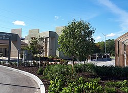
 East St. Paul municipal office | |
 Location of the RM of East St. Paul in Manitoba | |
| Coordinates: 49°58′38″N 97°00′37″W / 49.97722°N 97.01028°W | |
| Canada | Canada |
| Province | Manitoba |
| Region | Interlake and Winnipeg Metro |
| Founded (St. Paul) | 1888 |
| Incorporated (East St. Paul) | October 23, 1915 |
| Government | |
| • Mayor | Carla Devlin |
| • MLA Red River North | Jeff Wharton |
| Area | |
| • Total | 41.79 km2 (16.14 sq mi) |
| Elevation | 233 m (764 ft) |
| Population (2021)[2] | |
| • Total | 9,725 |
| • Density | 230/km2 (600/sq mi) |
| Time zone | UTC-6 (CST) |
| • Summer (DST) | UTC-5 (CDT) |
| Forward sortation area | |
| Area codes | 204, 431 |
| Website | http://www.eaststpaul.com/ |
East St. Paul is a rural municipality (RM) in Manitoba, Canada. It is located north-east of and adjacent to the city of Winnipeg, and is part of the Winnipeg Metropolitan Area. The municipality was formed on 3 November 1915 when the municipality of St. Paul (1888-1914) was subdivided into West St. Paul and East St. Paul,[3] with the Red River acting as the dividing line.
It encompasses 41 square kilometres (16 sq mi). In 2016, there were 9,372 persons living in the RM of East St. Paul, making it the most densely-populated RM in Manitoba at 223.2 inhabitants per square kilometre (578/sq mi).[2]
- ^ "Detail on East St. Paul Manitoba". Retrieved February 10, 2008.
- ^ a b "2021 Census Profile - East St. Paul". Statistics Canada. Retrieved March 30, 2023.
- ^ "Manitoba Municipalities: St. Paul". Manitoba Historical Society: Historic Places in Manitoba. Manitoba Historical Society. Retrieved October 16, 2015.
