Back مقاطعة ساكرامينتو (كاليفورنيا) Arabic مقاطعة ساكرامنتو ، كاليفورنيا ARZ Sakramento qraflığı (Kaliforniya) Azerbaijani Sacramento County, Kalifornien BAR Сакрамэнта (акруга, Каліфорнія) BE-X-OLD Сакраменто (окръг) Bulgarian সাক্রামেন্টো কাউন্টি, ক্যালিফোর্নিয়া BPY Сакраменто (гуо, Калифорни) CE Sacramento County CEB Sacramento County Czech
Sacramento County | |
|---|---|
| County of Sacramento | |
|
Images, from top down, left to right: California State Capitol, Folsom Powerhouse State Historic Park, Stone Lakes National Wildlife Refuge, Sutter's Fort | |
 Interactive map of Sacramento County | |
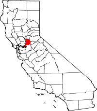
 Location in the state of California | |
| Coordinates: 38°27′N 121°21′W / 38.45°N 121.35°W | |
| Country | United States |
| State | California |
| Region | Sacramento Valley, San Joaquin Valley, Sacramento–San Joaquin River Delta |
| Metro area | Greater Sacramento |
| Incorporated | February 18, 1850[1] |
| Named for | The capital city of Sacramento, which is named for the Sacrament of the Holy Eucharist |
| County seat (and largest city) | Sacramento |
| Government | |
| • Type | Council–CEO |
| • Body | Board of Supervisors |
| • Chair[2] | Patrick Kennedy |
| • Vice Chair[2] | Phil Serna |
| • Board of Supervisors[2] | Supervisors
|
| • County Executive | David Villanueva |
| Area | |
• Total | 994 sq mi (2,570 km2) |
| • Land | 965 sq mi (2,500 km2) |
| • Water | 29 sq mi (80 km2) |
| Highest elevation | 831 ft (253 m) |
| Population | |
• Total | 1,585,055 |
• Estimate (2023) | 1,584,288 |
| • Density | 1,600/sq mi (620/km2) |
| Gross Domestic Product | |
| • Total | US$98.990 billion (2022) |
| Time zone | UTC−8 (Pacific Standard Time) |
| • Summer (DST) | UTC−7 (Pacific Daylight Time) |
| Area code(s) | 209, 916 |
| Congressional districts | 3rd, 6th, 7th |
| Website | saccounty |
Sacramento County (/ˌsækrəˈmɛntoʊ/ ⓘ) is a county located in the U.S. state of California. As of the 2020 census, the population was 1,585,055.[6] Its county seat is Sacramento,[7] which has been the state capital of California since 1854.
Sacramento County is the central county of the Greater Sacramento metropolitan area. The county covers about 994 square miles (2,570 km2) in the northern portion of the Central Valley, on into Gold Country. Sacramento County extends from the low delta lands between the Sacramento River and San Joaquin River, including Suisun Bay, north to about ten miles (16 km) beyond the State Capitol and east into the foothills of the Sierra Nevada Mountains. The southernmost portion of Sacramento County has direct access to San Francisco Bay. Since 2010, statewide droughts in California have further strained Sacramento County's water security.[8]
- ^ "Chronology". California State Association of Counties. Archived from the original on January 29, 2016. Retrieved February 6, 2015.
- ^ a b c "County Board of Supervisors".
- ^ Carpenter Hill
- ^ "State & County QuickFacts". United States Census Bureau. Archived from the original on July 3, 2011. Retrieved April 6, 2016.
- ^ "Gross Domestic Product by County and Metropolitan Area, 2022" (PDF). www.bea.gov. Bureau of Economic Analysis.
- ^ "Sacramento County, California". United States Census Bureau. Retrieved January 30, 2022.
- ^ "Find a County". National Association of Counties. Retrieved June 7, 2011.
- ^ McGough, Michael (April 29, 2022). "Southern California gets drastic water cutbacks amid drought. What's next for Sacramento?". amp.sacbee.com. Sacramento, California: The Sacramento Bee. Archived from the original on May 13, 2023. Retrieved June 5, 2023.


