Back تيزي ARY Седловина Bulgarian Collada Catalan Horské sedlo Czech Bergsattel German Montselo Esperanto Collado de montaña Spanish Lepo (geografia) Basque زین (زمینچهر) Persian Selle (géologie) French

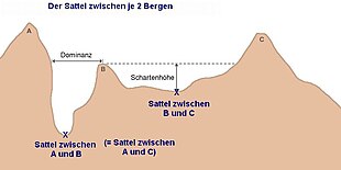
• There are three peaks (Schartenhöhe) or prominences shown labeled 'A', 'B', & 'C'.
• The diagram illustrates the topographic isolation (German: Dominanz)-the distance from a prominence which is also a minimum to the point of the same height.
• The 'isolation' (German: Dominanz) of the right two peaks is not labeled, but is represented by the dashed line.
• "sattel zwischen" means saddle between, so the labeling is saying the saddle between A and C is the same saddle as between A and B

The saddle between two hills or mountains is the region surrounding the saddle point, the lowest point on the line tracing the drainage divide (the col) connecting the peaks. When, and if, the saddle is navigable, even if only on foot, the saddle of a (optimal) pass between the two massifs, is the area generally found around the lowest route on which one could pass between the two summits, which includes that point which is a mathematically when graphed a relative high along one axis, and a relative low in the perpendicular axis, simultaneously; that point being by definition the col of the saddle.[citation needed]