Back Digue de Saemangeum French Dinding Laut Saemangeum ID Diga di Saemangeum Italian 새만금 방조제 Korean Saemangeumdemningen NB Сэмангым Russian Saemangeumska pregrada Slovenian Семангим (дамба) Ukrainian 新万金海堤 Chinese
| Saemangeum Seawall | |
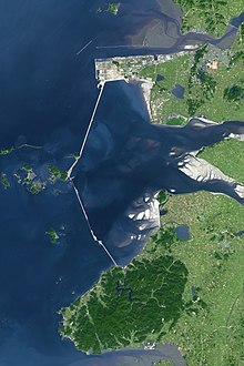
 Picture taken by NASA in October 2006. The city at the top of the picture is Gunsan City and the below is Buan County. | |
| Korean name | |
|---|---|
| Hangul | 새만금 방조제 |
| Hanja | 새萬金防潮堤 |
| Revised Romanization | Saemangeum bangjoje |
| McCune–Reischauer | Saeman'gŭm pangjoje |
The Saemangeum Seawall (Korean: 새만금 방조제), on the south-west coast of the Korean peninsula, is the world's longest man-made dyke, measuring 33 kilometres (21 mi). It runs between two headlands, and separates the Yellow Sea and the former Saemangeum estuary.
It was built to reclaim land for both agriculture and urban uses, including industrial uses,[1] and 401 km2 of the estuary was planned to be developed into an artificial lake (118 km2) and relaimed land (283 km2 ) that would provide nearly 10% of South Korea's total rice production.[1]
It is said to be the world's largest wetland reclamation,[1] and the various controversies, court cases and commissions led in part to the Wetland Conservation Act of 1999 (amended 2014),[2] which should both prevent the future loss of wetlands and help with wetland restoration.[1]
- ^ a b c d Koh Chul-hwan; Ryu Jongseong; Khim Jong Seong (November 2010). "The Saemangeum: History and Controversy" (PDF). Journal of the Korean Society of Marine and Environmental Engineering (in Korean and English). 13 (4): 327–344. Wikidata Q123508483.
- ^ "습지보전법 Wetland Conservation Act". www.law.go.kr. Retrieved 22 November 2023.