Back مديرية ساجارماثا Arabic सगरमाथा अञ्चल AWA Сагарматха (зона в Непал) Bulgarian सगरमाथा अंचल Bihari সগরমাথা অঞ্চল Bengali/Bangla Sagarmāthā Zone CEB Sagarmatha (Zone) German सगरमाथा अञ्चल DTY Zona de Sagarmatha Spanish Sagarmatha Gunea Basque
Sagarmāthā Zone
सगरमाथा अञ्चल | |
|---|---|
 | |
 | |
| Country | |
| Time zone | UTC+5:45 (Nepal Time) |
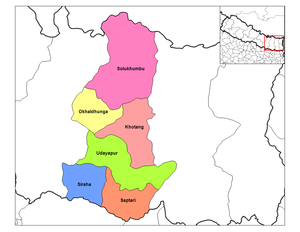
Sagarmāthā Zone (Nepali: सगरमाथा अञ्चल, [sʌgʌrmatʰa ʌnt͡sʌl] "Sagarmāthā Anchal") was one of the fourteen zones of Nepal until the restructuring of zones into provinces. The headquarters of Sagarmatha is Rajbiraj. Sagarmāthā is a Nepali word which as per some sources, is derived from सगर ("sagar", sky) and माथा ("māthā", head).
It includes mountain districts of the Himalayas (including the world's highest peak Mount Everest)[1] in the north, hill districts in the center, and valley districts of the Terai in the south. It is bordered by China to the north, India to the south,[2] the Kosi Zone to the east and the Janakpur Zone to the west.
- ^ yukesh0007 (2019-02-17). "Undisputed glory tales of Mt.Everest". SOUL OF HIMALAYAS. Retrieved 2020-01-28.
{{cite web}}: CS1 maint: numeric names: authors list (link) - ^ "Sacred Himalayan Landscape". 2013-06-12. Archived from the original on 2013-06-12. Retrieved 2018-09-03.