Back نهر ساجيناو ARZ ساقیناو چایی AZB Riu Saginaw Catalan Saginaw River CEB Saginaw River German Río Saginaw Spanish Rivière Saginaw French Saginawelva NN Сагино (река) Serbian 薩基諾河 Chinese
| Saginaw River | |
|---|---|
 | |
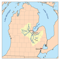
 Saginaw River watershed | |
| Location | |
| Country | United States |
| State | Michigan |
| Counties | Saginaw County, Bay County |
| Cities | Saginaw, Zilwaukee, Bay City, Essexville |
| Physical characteristics | |
| Source | confluence of Shiawassee River and Tittabawassee River |
| • location | Saginaw |
| • coordinates | 43°23′14″N 83°57′58″W / 43.387248°N 83.9660845°W[1] |
| • elevation | 577 ft (176 m)[2] |
| Mouth | Saginaw Bay |
• location | boundary of Bangor and Hampton townships |
• coordinates | 43°38′49″N 83°51′02″W / 43.6469667°N 83.8505319°W[1] |
• elevation | 571 ft (174 m)[1] |
| Length | 22 mi (35 km) |
| Basin size | 8,595 sq mi (22,260 km2) |
| Discharge | |
| • location | mouth |
| • average | 4,827 cubic feet per second (136.7 m3/s) (estimate) |
The Saginaw River is a 22.4-mile-long (36.0 km)[3] river in the U.S. state of Michigan. It is formed by the confluence of the Tittabawassee and Shiawassee rivers southwest of Saginaw. It flows northward into the Saginaw Bay of Lake Huron, passing through the cities of Saginaw and Bay City, both of which developed around it in the 19th century. The watershed area is 8,595 square miles (22,260 km2).[4] At its mouth, the river's estimated average discharge is 4,827 cubic feet per second (136.7 m3/s).[5]
The river is an important shipping route for Mid-Michigan, passing through the cities of Saginaw and Bay City. It is one of Michigan's few inland navigable rivers. The Saginaw River Rear Range Light, one of a pair of lighthouses built in 1876 to improve navigation, was listed on the National Register of Historic Places in 1984. Since the turn of the 21st century, it is being renovated.
- ^ a b c "Saginaw River". Geographic Names Information System. United States Geological Survey, United States Department of the Interior.
- ^ "Shiawassee River". Geographic Names Information System. United States Geological Survey, United States Department of the Interior.
- ^ U.S. Geological Survey. National Hydrography Dataset high-resolution flowline data. The National Map, accessed November 7, 2011
- ^ Saginaw River Archived 2011-05-14 at the Wayback Machine Great Lakes Commission
- ^ "Saginaw River Watershed Report | Office of Water | US EPA". watersgeo.epa.gov. Archived from the original on 2021-04-03. Retrieved 2021-04-03.