Back Saint-Marc-de-Figuery CEB Saint-Marc-de-Figuery (Quebec) Basque سن-مارک-دو-فیگری، کبک Persian Saint-Marc-de-Figuery French Saint-Marc-de-Figuery Swedish سینٹ-مارک-دے-فگیرے، کیوبک Urdu
Saint-Marc-de-Figuery | |
|---|---|
 Route 111 through St-Marc-de-Figuery | |
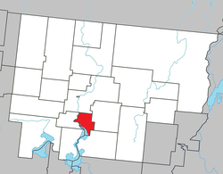
 Location within Abitibi RCM | |
| Coordinates: 48°28′N 78°03′W / 48.467°N 78.050°W[1] | |
| Country | Canada |
| Province | Quebec |
| Region | Abitibi-Témiscamingue |
| RCM | Abitibi |
| Settled | c. 1915 |
| Constituted | November 10, 1926 |
| Government | |
| • Mayor | André Rioux |
| • Federal riding | Abitibi—Témiscamingue |
| • Prov. riding | Abitibi-Ouest |
| Area | |
| • Total | 92.80 km2 (35.83 sq mi) |
| • Land | 80.79 km2 (31.19 sq mi) |
| Population (2021)[3] | |
| • Total | 868 |
| • Density | 10.7/km2 (28/sq mi) |
| • Pop (2016-21) | |
| • Dwellings | 386 |
| Time zone | UTC−5 (EST) |
| • Summer (DST) | UTC−4 (EDT) |
| Postal code(s) | |
| Area code | 819 |
| Highways | |
| Website | www |
Saint-Marc-de-Figuery is a parish municipality in the Canadian province of Quebec, located in the Abitibi Regional County Municipality. It is part of the census agglomeration of Amos.
- ^ Cite error: The named reference
toponymiewas invoked but never defined (see the help page). - ^ a b "Saint-Marc-de-Figuery". Répertoire des municipalités (in French). Ministère des Affaires municipales et de l'Habitation. Retrieved 2023-07-27.
- ^ a b Cite error: The named reference
SC21was invoked but never defined (see the help page).
