Back جبال سان غابرييل Arabic جبال سان جبرائيل ARZ San Gabriel Mountains Catalan San Gabriel Mountains CEB چیای سان گابریل CKB San Gabriel Mountains Czech San Gabriel Mountains German Montaro San Gabriel Esperanto Sierra de San Gabriel Spanish San Gabrieli mäed Estonian
| San Gabriel Mountains | |
|---|---|
 Summits in the eastern San Gabriel Mountains, Angeles National Forest, San Bernardino County, California. The main peaks are: Telegraph Peak 8,985 feet (2,739 m) (left), Cucamonga Peak, 8,859 feet (2,700 m) (center), and Ontario Peak 8,693 feet (2,650 m) (center right), as seen from Baldy Bowl on Mount Baldy. | |
| Highest point | |
| Peak | Mount San Antonio |
| Elevation | 10,069 ft (3,069 m) |
| Coordinates | 34°17′20″N 117°38′48″W / 34.2889°N 117.6467°W |
| Dimensions | |
| Length | 68.4 mi (110.1 km) |
| Width | 22.5 mi (36.2 km) |
| Area | 970 sq mi (2,500 km2) |
| Geography | |
| Country | United States |
| State | California |
| Counties | |
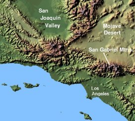
The San Gabriel Mountains (Spanish: Sierra de San Gabriel) comprise a mountain range located in northern Los Angeles County and western San Bernardino County, California, United States.[1] The mountain range is part of the Transverse Ranges and lies between the Los Angeles Basin and the Mojave Desert, with Interstate 5 to the west and Interstate 15 to the east. The range lies in, and is surrounded by, the Angeles and San Bernardino National Forests, with the San Andreas Fault as its northern border.
The highest peak in the range is Mount San Antonio, commonly referred to as Mt. Baldy. Mount Wilson is another notable peak, known for the Mount Wilson Observatory and the antenna farm that houses many of the transmitters for local media. The observatory may be visited by the public. On October 10, 2014, Barack Obama designated the area the San Gabriel Mountains National Monument.[2] The Trust for Public Land has protected more than 3,800 acres (1,500 ha) of land in the San Gabriel Mountains, its foothills, and the Angeles National Forest.[3]
- ^ "San Gabriel Mountains". Geographic Names Information System. United States Geological Survey, United States Department of the Interior. Retrieved May 3, 2009.
- ^ "President Obama Designates San Gabriel Mountains National Monument". whitehouse.gov. October 10, 2014. Retrieved October 10, 2014 – via National Archives.
- ^ "Los Angeles Natural Lands". The Trust for Public Land. Retrieved August 3, 2018.
