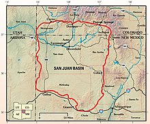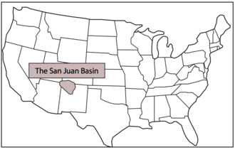

The San Juan Basin is a geologic structural basin located near the Four Corners region of the Southwestern United States. The basin covers 7,500 square miles and resides in northwestern New Mexico, southwestern Colorado, and parts of Utah and Arizona. Specifically, the basin occupies space in the San Juan, Rio Arriba, Sandoval, and McKinley counties in New Mexico, and La Plata and Archuleta counties in Colorado. The basin extends roughly 100 miles (160 km) N-S and 90 miles (140 km) E-W.[2]

The San Juan Basin is an asymmetric structural depression in the Colorado Plateau province, with varying elevation and nearly 3,000 feet (910 m) in topographic relief. Its most striking features include Chaco Canyon (northwestern New Mexico, between Farmington and Santa Fe) and Chacra Mesa. The basin lies west of the Continental Divide, and its main drainage is the southwest- to west-flowing San Juan River, which eventually joins the Colorado River in Utah. Climate of the basin is arid to semiarid, with an annual precipitation of 15 in (380 mm) and an average annual temperature of around 50 °F (10 °C).[2]
The San Juan Basin has been a major producer of oil and natural gas since the early 20th century, with currently more than 300 oil fields and over 40,000 drilled wells throughout the area. As of 2009, cumulative production reached 42.6 trillion cubic feet of gas and 381 million barrels of oil. The area is especially known for gas reservoirs from its coal-bed methane formations. The San Juan Basin contains the largest coal-bed methane field in the world and ranks second in total gas reserves.[2][3]
- ^ "Boundary Descriptions and Names of Regions, Subregions, Accounting Units and Cataloging Units". U.S. Geological Survey. Retrieved December 27, 2010.
- ^ a b c Fassett, James E.; Hinds, Jim S. (1971). "Geology and fuel resources of the Fruitland Formation and Kirtland Shale of the San Juan Basin, New Mexico and Colorado". Geological Survey Professional Paper. Professional Paper. 676. doi:10.3133/pp676.
- ^ Fassett, James E. (2010). "Oil and gas resources of the San Juan Basin, New Mexico and Colorado" (PDF). New Mexico Geological Society Guidebook. 61st Field Conference: 181–196. Retrieved November 12, 2020.
