Back Sanchez Mira BCL Sanchez Mira CBK-ZAM Sanchez Mira CEB Sanchez Mira German Sánchez Mira Spanish Sanchez Mira French Sanchez Mira ID Sanchez Mira ILO Sanchez-Mira Italian სანჩეს-მირა Georgian
This article possibly contains original research. (March 2016) |
Sanchez Mira
Malolokit | |
|---|---|
| Municipality of Sanchez Mira | |
 A private elementary school at Sanchez Mira | |
| Motto: Dur-as Sanchez Mira! | |
| Anthem: Sanchez Mira Hymn | |
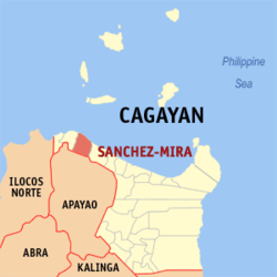
 Map of Cagayan with Sanchez-Mira highlighted | |
Location within the Philippines | |
| Coordinates: 18°33′40″N 121°14′04″E / 18.5611°N 121.2344°E | |
| Country | Philippines |
| Region | Cagayan Valley |
| Province | Cagayan |
| District | 2nd district |
| Founded | 1887 |
| Barangays | 18 (see Barangays) |
| Government | |
| • Type | Sangguniang Bayan |
| • Mayor | Abraham B. Bagasin |
| • Vice Mayor | Asela Bagasin-Sacramed |
| • Representative | Baby Aline V. Alfonso |
| • Electorate | 18,189 voters (2022) |
| Area | |
| • Total | 198.80 km2 (76.76 sq mi) |
| Elevation | 61 m (200 ft) |
| Highest elevation | 1,261 m (4,137 ft) |
| Lowest elevation | 0 m (0 ft) |
| Population (2020 census)[3] | |
| • Total | 26,164 |
| • Density | 130/km2 (340/sq mi) |
| • Households | 6,645 |
| Economy | |
| • Income class | 3rd municipal income class |
| • Poverty incidence | 8.13 |
| • Revenue | ₱ 147.3 million (2020) |
| • Assets | ₱ 497.2 million (2020) |
| • Expenditure | ₱ 118.4 million (2020) |
| • Liabilities | ₱ 86.78 million (2020) |
| Service provider | |
| • Electricity | Cagayan 2 Electric Cooperative (CAGELCO 2) |
| Time zone | UTC+8 (PST) |
| ZIP code | 3518 |
| PSGC | |
| IDD : area code | +63 (0)78 |
| Native languages | Ibanag Ilocano Tagalog |
| Major religions | Pentecost, IAFB, AFB, Assembly of the first born, Catholic, IFI, Methodist |
| Feast date | August 16 |
| Patron saint | St. Roche |
| Website | www |
Sanchez Mira, officially the Municipality of Sanchez Mira (Ibanag: Ili nat Sanchez Mira; Ilocano: Ili ti Sanchez Mira; Tagalog: Bayan ng Sanchez Mira), is a 3rd class municipality in the province of Cagayan, Philippines. According to the 2020 census, it has a population of 26,164 people.[3]
It is 155 kilometres (96 mi) from the provincial capital Tuguegarao and 632 kilometres (393 mi) from Manila. Lying on a latitude of 18 degrees, 34 minutes north and a longitude of 121 degrees, 14 minutes east, the municipality is bounded on the north by the Babuyan Channel; on the south by the municipality of Luna, Apayao; on the east by the municipality of Pamplona, Cagayan; and on the west by the municipality of Claveria, Cagayan.
- ^ Municipality of Sanchez Mira | (DILG)
- ^ "2015 Census of Population, Report No. 3 – Population, Land Area, and Population Density" (PDF). Philippine Statistics Authority. Quezon City, Philippines. August 2016. ISSN 0117-1453. Archived (PDF) from the original on May 25, 2021. Retrieved July 16, 2021.
{{cite web}}: CS1 maint: year (link) - ^ a b Census of Population (2020). "Region II (Cagayan Valley)". Total Population by Province, City, Municipality and Barangay. Philippine Statistics Authority. Retrieved 8 July 2021.
- ^ "PSA Releases the 2021 City and Municipal Level Poverty Estimates". Philippine Statistics Authority. 2 April 2024. Retrieved 28 April 2024.


