Back سانتا آنا (كاغيان) Arabic Santa Ana, Cagayan BCL Santa Ana, Cagayan CBK-ZAM Santa Ana, Cagayan CEB Santa Ana (Cagayan) German Santa Ana (Cagayán) Spanish Santa Ana (Cagayan) French Santa Ana, Cagayan ID Santa Ana, Cagayan ILO Santa Ana (Cagayan) Italian
This article needs additional citations for verification. (January 2014) |
Santa Ana | |
|---|---|
| Municipality of Santa Ana | |
 View of Santa Ana coast from Mount Cagua | |
| Nickname: Game Fishing Center of the Philippines | |
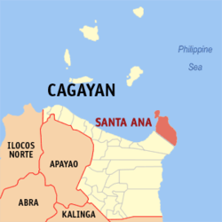
 Map of Cagayan with Santa Ana highlighted | |
Location within the Philippines | |
| Coordinates: 18°27′32″N 122°08′31″E / 18.4589°N 122.1419°E | |
| Country | Philippines |
| Region | Cagayan Valley |
| Province | Cagayan |
| District | 1st district |
| Founded | October 21, 1949 |
| Barangays | 16 (see Barangays) |
| Government | |
| • Type | Sangguniang Bayan |
| • mayor of Santa Ana[*] | Nelson P. Robinion |
| • Vice Mayor | Catherine J. Ladrido |
| • Representative | Ramon C. Nolasco Jr. |
| • Electorate | 23,532 voters (2022) |
| Area | |
| • Total | 441.30 km2 (170.39 sq mi) |
| Elevation | 64 m (210 ft) |
| Highest elevation | 1,142 m (3,747 ft) |
| Lowest elevation | 0 m (0 ft) |
| Population (2020 census)[3] | |
| • Total | 35,688 |
| • Density | 81/km2 (210/sq mi) |
| • Households | 8,203 |
| Economy | |
| • Income class | 2nd municipal income class |
| • Poverty incidence | 13.19 |
| • Revenue | ₱ 209.1 million (2020) |
| • Assets | ₱ 571.2 million (2020) |
| • Expenditure | ₱ 181.4 million (2020) |
| • Liabilities | ₱ 159.3 million (2020) |
| Service provider | |
| • Electricity | Cagayan 2 Electric Cooperative (CAGELCO 2) |
| Time zone | UTC+8 (PST) |
| ZIP code | 3514 |
| PSGC | |
| IDD : area code | +63 (0)78 |
| Native languages | Ibanag Ilocano Dupaningan Agta Tagalog |
| Website | https://santaanacagayan.gov.ph/ |
Santa Ana, officially the Municipality of Santa Ana (Ibanag: Ili nat Santa Ana; Ilocano: Ili ti Santa Ana; Tagalog: Bayan ng Santa Ana), is a 2nd class municipality in the province of Cagayan, Philippines. In the 2020 census, it had a population of 35,688 people.[3]
The municipality contains the north-easternmost point of Luzon and also includes Palaui Island. It is the home of the Cagayan Special Economic Zone and the Camilo Osias Naval Base in Barangay San Vicente. Santa Ana is 154 kilometres (96 mi) from Tuguegarao and 635 kilometres (395 mi) from Manila.
- ^ Municipality of Santa Ana | (DILG)
- ^ "2015 Census of Population, Report No. 3 – Population, Land Area, and Population Density" (PDF). Philippine Statistics Authority. Quezon City, Philippines. August 2016. ISSN 0117-1453. Archived (PDF) from the original on May 25, 2021. Retrieved July 16, 2021.
- ^ a b Census of Population (2020). "Region II (Cagayan Valley)". Total Population by Province, City, Municipality and Barangay. Philippine Statistics Authority. Retrieved 8 July 2021.
- ^ "PSA Releases the 2021 City and Municipal Level Poverty Estimates". Philippine Statistics Authority. 2 April 2024. Retrieved 28 April 2024.


