Back Taman Nasional Schiermonnikoog BAN Národní park Schiermonnikoog Czech Nationalpark Schiermonnikoog German Parque nacional Schiermonnikoog Spanish Parc national Schiermonnikoog French Nasjonaal Park Skiermûntseach Frisian Parco nazionale di Schiermonnikoog Italian სხირმონიკოგის ეროვნული პარკი Georgian Nationaal Park Schiermonnikoog Dutch Park Narodowy Schiermonnikoog Polish
| Schiermonnikoog National Park | |
|---|---|
| Nationaal Park Schiermonnikoog | |
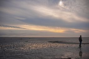
 Landscape in Schiermonnikoog National Park | |
Map of the Netherlands | |
| Location | Schiermonnikoog, Friesland, Netherlands |
| Coordinates | 53°29′21″N 6°13′55″E / 53.4893°N 6.232°E |
| Area | 72 km2 (28 sq mi) |
| Established | 1989 |
| www | |
| Official name | Duinen Schiermonnikoog |
| Designated | 29 August 2000 |
| Reference no. | 2214[1] |
Schiermonnikoog National Park is a national park in the Dutch province of Friesland. It was founded in 1989. It covers about 72 km2 (28 sq mi), the majority of the island Schiermonnikoog.
- ^ "Duinen Schiermonnikoog". Ramsar Sites Information Service. Retrieved 25 April 2018.
