| Seaham New South Wales | |||||||||||||||
|---|---|---|---|---|---|---|---|---|---|---|---|---|---|---|---|
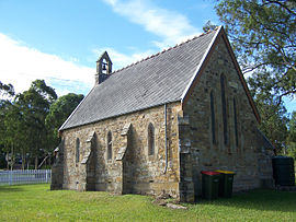
 St. Andrews Anglican Church, dedicated 1860 | |||||||||||||||
 | |||||||||||||||
| Coordinates | 32°39′54″S 151°43′04″E / 32.66500°S 151.71778°E | ||||||||||||||
| Population | 1,025 (2011 census)[2] | ||||||||||||||
| • Density | 23.9/km2 (62/sq mi) | ||||||||||||||
| Established | 1822 | ||||||||||||||
| Postcode(s) | 2324 | ||||||||||||||
| Area | 42.8 km2 (16.5 sq mi)[Note 1] | ||||||||||||||
| Time zone | AEST (UTC+10) | ||||||||||||||
| • Summer (DST) | AEDT (UTC+11) | ||||||||||||||
| Location |
| ||||||||||||||
| LGA(s) | Port Stephens Council[1] | ||||||||||||||
| Region | Hunter[1] | ||||||||||||||
| Parish | Seaham[3] | ||||||||||||||
| State electorate(s) | Port Stephens[4] | ||||||||||||||
| Federal division(s) | Lyne[5] | ||||||||||||||
| |||||||||||||||
| |||||||||||||||

Seaham[pronunciation?] is a suburb of the Port Stephens local government area in the Hunter Region of New South Wales, Australia.[1][7] It is located on the Williams River which flows into the Hunter River 14.6 km (9.1 mi) downstream from Seaham village at Raymond Terrace.
It is a rural community supporting a small but expanding population. While the actual village of Seaham, which is located in the north-eastern corner of the suburb, is relatively compact and composed of only a handful of streets, the suburb itself covers an area of approximately 42.8 km2 (16.5 sq mi).[7] At the 2011 census, Seaham had a population of 1,025.[2] Greater Seaham covers an even larger area and incorporates East Seaham, Brandy Hill, Eagleton and Eskdale Estate.
- ^ a b c "Suburb Search – Local Council Boundaries – Hunter (HT) – Port Stephens". New South Wales Division of Local Government. Retrieved 10 June 2008.
- ^ a b Australian Bureau of Statistics (31 October 2012). "Seaham (State Suburb)". 2011 Census QuickStats. Retrieved 17 October 2012.
- ^ "Seaham". Geographical Names Register (GNR) of NSW. Geographical Names Board of New South Wales. Retrieved 10 June 2008.
- ^ "Port Stephens". New South Wales Electoral Commission. Retrieved 23 November 2019.
- ^ "Paterson". Australian Electoral Commission. 19 October 2007. Archived from the original on 29 October 2009. Retrieved 10 June 2008.
- ^ a b c "Paterson (Tocal AWS)". Climate statistics for Australian locations. Bureau of Meteorology. Retrieved 10 June 2008.
- ^ a b "Seaham". Land and Property Management Authority - Spatial Information eXchange. New South Wales Land and Property Information. Retrieved 10 June 2008.
Cite error: There are <ref group=Note> tags on this page, but the references will not show without a {{reflist|group=Note}} template (see the help page).

