Back Sedgefield Afrikaans Sedgefield (Sudafrica) Italian Sedgefield (Zuid-Afrika) Dutch Sedgefield, Kapa Bodikela NSO Sedgefield, Africa de Sud Romanian Меедінґсріде (ПАР) Ukrainian سیج فیلڈ، مغربی کیپ Urdu ISedgefield, INtshonalanga Kapa Zulu
Sedgefield | |
|---|---|
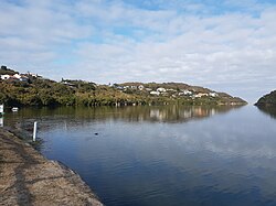
 The Swartvlei with Sedgefield seen in the background | |
| Coordinates: 34°01′17″S 22°48′12″E / 34.02139°S 22.80333°E | |
| Country | South Africa |
| Province | Western Cape |
| District | Garden Route |
| Municipality | Knysna |
| Area | |
| • Total | 7.85 km2 (3.03 sq mi) |
| Population (2011)[1] | |
| • Total | 8,286 |
| • Density | 1,100/km2 (2,700/sq mi) |
| Racial makeup (2011) | |
| • Black African | 24.8% |
| • Coloured | 29.5% |
| • Indian/Asian | 0.3% |
| • White | 42.8% |
| • Other | 2.6% |
| First languages (2011) | |
| • Afrikaans | 48.8% |
| • English | 26.7% |
| • Xhosa | 18.2% |
| • Sotho | 1.2% |
| • Other | 5.1% |
| Time zone | UTC+2 (SAST) |
| Postal code (street) | 6573 |
| PO box | 6573 |
| Area code | 044 |
Sedgefield is a coastal town on the Garden Route in the Western Cape province of South Africa. It is situated on the N2 national road, between George and Knysna.
The town was proclaimed in 1929 on the farm Sedgefield, which in turn was named in 1894 after the village of the same name in the UK where the father (Henry Barrington) of the then farm owner was born.
- ^ a b c d "Main Place Sedgefield". Census 2011.

