Back Selby District CEB Ardal Selby Welsh Selby District German Distrito de Selby Spanish Selby (district) French Selby (distretto) Italian 셀비구 Korean Selby (district) Dutch Selby (distrikt) NB Selby (dystrykt) Polish
Selby District | |
|---|---|
 Selby District Community House | |
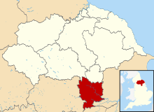
 Shown within North Yorkshire | |
| Sovereign state | United Kingdom |
| Constituent country | England |
| Region | Yorkshire and the Humber |
| Shire county | North Yorkshire |
| Admin. HQ | Selby |
| Government | |
| • Type | Selby District Council |
| • Leadership: | Leader and Executive |
| • Executive: | |
| Area | |
| • Total | 231.4 sq mi (599.3 km2) |
| Population (2021) | |
| • Total | 92,401 |
| • Density | 400/sq mi (150/km2) |
| Time zone | UTC+0 (Greenwich Mean Time) |
| • Summer (DST) | UTC+1 (British Summer Time) |
| ONS code | 36UH (ONS) E07000169 (GSS) |
| Ethnicity | 92.3% White |
| Website | selby.gov.uk |
Selby District was a local government district of North Yorkshire, England, from 1974 to 2023. Its council was based in the town of Selby. The district had a population of 83,449 at the 2011 Census.[1] The southernmost district of North Yorkshire, it bordered the City of York unitary authority, the Borough of Harrogate in North Yorkshire, the City of Leeds and City of Wakefield districts in West Yorkshire, the City of Doncaster in South Yorkshire, and the ceremonial county of the East Riding of Yorkshire.
- ^ UK Census (2011). "Local Area Report – Selby Local Authority (E07000169)". Nomis. Office for National Statistics. Retrieved 5 March 2020.
