Back سينيكا (كارولاينا الجنوبية) Arabic سينيكا (اوكونى) ARZ سنیکا، گونئی کارولینا AZB Seneca (Carolina del Sud) Catalan Сенека (Къилба Каролина) CE Seneca (lungsod sa Tinipong Bansa, South Carolina) CEB Seneca, De Carolina Welsh Seneca (South Carolina) German Seneca (Carolina del Sur) Spanish Seneca (Hego Carolina) Basque
Seneca, South Carolina | |
|---|---|
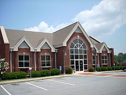
 Seneca City Hall | |
| Motto(s): "City of Smiles, City with Style" | |
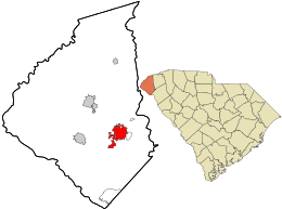
 Location in Oconee County and the state of South Carolina. | |
| Coordinates: 34°41′3″N 82°57′21″W / 34.68417°N 82.95583°W | |
| Country | United States |
| State | South Carolina |
| County | Oconee |
| Government | |
| • Mayor | Daniel W. Alexander |
| Area | |
| • Total | 8.30 sq mi (21.49 km2) |
| • Land | 8.24 sq mi (21.35 km2) |
| • Water | 0.05 sq mi (0.14 km2) |
| Elevation | 951 ft (290 m) |
| Population | |
| • Total | 8,850 |
| • Density | 1,073.64/sq mi (414.55/km2) |
| Time zone | UTC−5 (Eastern (EST)) |
| • Summer (DST) | UTC−4 (EDT) |
| ZIP codes | 29672, 29678, 29679 |
| Area codes | 864, 821 |
| FIPS code | 45-65095[4] |
| GNIS feature ID | 1250833[2] |
| Website | www |
Seneca is a city in Oconee County, South Carolina, United States. The population was 8,102 at the 2010 census. It is the principal city of the Seneca Micropolitan Statistical Area (population 74,273 at the 2010 census), an (MSA) that includes all of Oconee County, and that is included within the greater Greenville-Spartanburg-Anderson, South Carolina Combined Statistical Area (population 1,266,995 at the 2010 census). Seneca was named for the nearby Cherokee town of Isunigu, which English colonists knew as "Seneca Town".
- ^ "ArcGIS REST Services Directory". United States Census Bureau. Retrieved October 15, 2022.
- ^ a b U.S. Geological Survey Geographic Names Information System: Seneca, South Carolina
- ^ Cite error: The named reference
USCensusDecennial2020CenPopScriptOnlywas invoked but never defined (see the help page). - ^ "U.S. Census website". United States Census Bureau. Retrieved January 31, 2008.

