Back سينج (مدينة) Arabic سنج (تجمع سكان فى مقاطعه ليكا سنى) ARZ Сень Byelorussian Сен (град) Bulgarian Senj Breton Senj BS Senj Catalan Senj (lungsod) CEB سێنی CKB Senj Czech
Senj | |
|---|---|
| Grad Senj Town of Senj | |
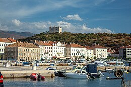
Clockwise, from top: Senj harbour, City walls, medieval city hall, Nehaj, Co-Cathedral of the Assumption of Mary, Senj, Bell tower of the Co-Cathedral | |
 | |
| Coordinates: 44°59′24.52″N 14°54′10.96″E / 44.9901444°N 14.9030444°E | |
| Country | |
| County | |
| Government | |
| • Mayor | Jurica Tomljanović (HDZ) |
| • Town Council | 13 members |
| Area | |
| • Town | 657.9 km2 (254.0 sq mi) |
| • Urban | 3.2 km2 (1.2 sq mi) |
| Elevation | 0 m (0 ft) |
| Population (2021)[2] | |
| • Town | 5,973 |
| • Density | 9.1/km2 (24/sq mi) |
| • Urban | 4,164 |
| • Urban density | 1,300/km2 (3,400/sq mi) |
| Time zone | UTC+1 (CET) |
| • Summer (DST) | UTC+2 (CEST) |
| Postal code | 53 270 |
| Area code | 053 |
| Website | senj |
Senj (Croatian: [sêɲ];[3] Italian: Segna; Latin: Senia; Hungarian and German: Zengg) is a town on the upper Adriatic coast in Croatia, in the foothills of the Mala Kapela and Velebit mountains.
The symbol of the town is the Nehaj Fortress (Croatian: Tvrđava Nehaj) which was completed in 1558. For a time this was the seat of the Uskoks (Italian: Uscocchi), who were Christian refugees from Ottoman Bosnia resettled here to protect the Habsburg borderlands. The Republic of Venice accused the Uskoks of piracy and declared war on them which led to their expulsion following a truce in 1617.
Senj is to be found in the Lika-Senj County of Croatia, the Roman Catholic Diocese of Gospić-Senj and the Roman Catholic Archdiocese of Rijeka.
- ^ Register of spatial units of the State Geodetic Administration of the Republic of Croatia. Wikidata Q119585703.
- ^ "Population by Age and Sex, by Settlements" (xlsx). Census of Population, Households and Dwellings in 2021. Zagreb: Croatian Bureau of Statistics. 2022.
- ^ Deanović, Mirko; Jernej, Josip (1975). "Sȅnj". Hrvatsko ili srpsko-talijanski rječnik (4th ed.). Zagreb: Školska knjiga.


