Back Sierra d'Ancares AST Serra dels Ancares Catalan Serra dos Ancares CEB Sierra de Ancares Spanish Serra dos Ancares Basque Sierra de Ancares French Serra dos Ancares Galician Սիեռա դե Անկարես Armenian Sierra de Ancares NN Serra dos Ancares Portuguese
| Serra dos Ancares | |
|---|---|
| Sierra de los Ancares | |
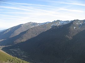
 General view of the range | |
| Highest point | |
| Peak | Cuiña |
| Elevation | 1,987 m (6,519 ft) |
| Coordinates | 42°46′05″N 6°53′53″W / 42.76806°N 6.89806°W |
| Dimensions | |
| Length | 95 km (59 mi) NE/SW |
| Width | 32 km (20 mi) NW/SE |
| Geography | |
| Location | Lugo Province, Galicia León Province, Castile and León |
| Country | Spain |
| Parent range | Galician Massif |
| Geology | |
| Orogeny | Variscan orogeny |
| Age of rock | Ordovician |
| Type of rock | Slate, limestone, sandstone, quartzite |
The Serra dos Ancares (Spanish: Sierra de los Ancares, also known as Sierra de Ancares) is a mountain range of the Galician Massif in north-west Spain, extending in a south-westerly direction from the western end of the Cantabrian Mountains in Asturias.
