Back Cuballing (rehiyon) CEB Cuballing Shire German Comté de Cuballing French Contea di Cuballing Italian Shire of Cuballing Dutch Shire of Cuballing Swedish
| Shire of Cuballing Western Australia | |||||||||||||||
|---|---|---|---|---|---|---|---|---|---|---|---|---|---|---|---|
 Cuballing shire offices, 2014 | |||||||||||||||
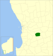
 Location in Western Australia | |||||||||||||||
 | |||||||||||||||
| Population | 902 (LGA 2021)[1] | ||||||||||||||
| Established | 1902 | ||||||||||||||
| Area | 1,195.4 km2 (461.5 sq mi) | ||||||||||||||
| Shire President | Eliza Dowling | ||||||||||||||
| Council seat | Cuballing | ||||||||||||||
| Region | Wheatbelt | ||||||||||||||
| State electorate(s) | Central Wheatbelt | ||||||||||||||
| Federal division(s) | O'Connor | ||||||||||||||
 | |||||||||||||||
| Website | Shire of Cuballing | ||||||||||||||
| |||||||||||||||
The Shire of Cuballing is a local government area in the Wheatbelt region of Western Australia. Cuballing is located 15.1 kilometres (9 mi) north of the town of Narrogin and 192 kilometres (119 mi) southeast of the capital, Perth. The Shire covers an area of 1,195 square kilometres (461 sq mi) and its seat of government is the small town of Cuballing.
Over 10% of its area contains native dryandra forests. The economy, worth approximately $20 million per year to the state economy, is based on agriculture, with cereal grains, sheep and pig farming being the main activities.[2]
- ^ Australian Bureau of Statistics (28 June 2022). "Cuballing (Local Government Area)". Australian Census 2021 QuickStats. Retrieved 28 June 2022.
- ^ Agriculture WA (July 2000). "Agriculture Statistical Overview 96/97 - Shire of Cuballing" (PDF). Archived from the original (PDF) on 17 September 2006. Retrieved 15 November 2006.