Back Halls Creek (rehiyon) CEB Halls Creek Shire German Comté de Halls Creek French Contea di Halls Creek Italian Shire of Halls Creek Dutch Hrabstwo Halls Creek Polish Halls Creek Shire Swedish
| Shire of Halls Creek Western Australia | |||||||||||||||
|---|---|---|---|---|---|---|---|---|---|---|---|---|---|---|---|
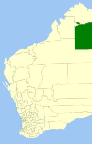
 Location in Western Australia | |||||||||||||||
 | |||||||||||||||
| Population | 3,574 (LGA 2021)[1] | ||||||||||||||
| Established | 1887 | ||||||||||||||
| Area | 143,030 km2 (55,224.2 sq mi) | ||||||||||||||
| President | Malcolm Edwards | ||||||||||||||
| Council seat | Halls Creek | ||||||||||||||
| Region | Kimberley | ||||||||||||||
| State electorate(s) | Kimberley | ||||||||||||||
| Federal division(s) | Durack | ||||||||||||||
 | |||||||||||||||
| Website | Shire of Halls Creek | ||||||||||||||
| |||||||||||||||
The Shire of Halls Creek is one of the four local government areas in the Kimberley region of northern Western Australia, covering an area of 143,030 square kilometres (55,224 sq mi), most of which is sparsely populated. The Shire's seat of government is the town of Halls Creek. Many Aboriginal communities are located within the shire.
The Purnululu National Park, home to part of the Bungle Bungle Range, and Gregory Lake are within the Shire, as is the Wolfe Creek Meteorite Crater National Park.
- ^ Australian Bureau of Statistics (28 June 2022). "Halls Creek (Local Government Area)". Australian Census 2021 QuickStats. Retrieved 28 June 2022.