Back سيبروت Arabic سيبروت ARZ Siberut AST Сіберут Byelorussian Siberut Catalan Pulau Siberut CEB Siberut Czech Siberut Danish Siberut German Σιμπέρουτ Greek
 | |
| Geography | |
|---|---|
| Location | South East Asia |
| Coordinates | 1°23′S 98°54′E / 1.383°S 98.900°E |
| Archipelago | Mentawai Islands |
| Area | 3,877.9 km2 (1,497.3 sq mi) |
| Highest elevation | 1,129 ft (344.1 m) |
| Highest point | Taitaibeuleleu |
| Administration | |
Indonesia | |
| Province | West Sumatra |
| Regency | Mentawai Islands |
| Demographics | |
| Population | 41,899 (mid 2023 estimate[1]) |
| Pop. density | 10.8/km2 (28/sq mi) |
| Ethnic groups | Mentawai. 10% of the population are from other parts of Indonesia. |
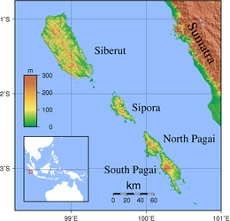
1°23′S 98°54′E / 1.383°S 98.900°E Siberut is the largest and northernmost of the Mentawai Islands, located 150 kilometres west of Sumatra in the Indian Ocean. It covers an area of 3,838.25 km2 including smaller offshore islands, and had a population of 35,091 at the 2010 Census[2] and 40,220 at the 2020 Census;[3] the official estimate as at mid 2023 was 41,899.[1] A part of Indonesia, the island is the most important home for the Mentawai people.[4] The western half of the island was set aside as the Siberut National Park in 1993. Much of the island is covered with rainforest, but is subject to commercial logging.
Smaller islands adjacent to Siberut include Karamajet and Masokut which lie in the Bungalaut Strait to the south of the island.
The island is known for its range of primates, including the Kloss gibbon (Hylobates klossii), pig-tailed langur (Simias concolor), Siberut langur (Presbytis siberu) and Mentawai macaque (Macaca pagensis).
Siberut was affected by the 2004 Indian Ocean earthquake tsunami, but without any known loss of human life. One report stated that the island may have been raised up to two metres by the earthquake.
- ^ a b Badan Pusat Statistik, Jakarta, 28 February 2024, Kabupaten Kepulauan Mentawai Dalam Angka 2024 (Katalog-BPS 1102001.1301)
- ^ Biro Pusat Statistik, Jakarta, 2011.
- ^ Badan Pusat Statistik, Jakarta, 2021.
- ^ Ryan Ver Berkmoes; Celeste Brash; Muhammad Cohen; Mark Elliott; Guyan Mitra; John Noble; Adam Skolnick; Iain Stewart; Steve Waters (2010). Lonely Planet Indonesia: Travel Guide (illustrated ed.). Lonely Planet. ISBN 978-1-742203485.