| Sierra Pelona | |
|---|---|
| Sierra Pelona Mountains | |
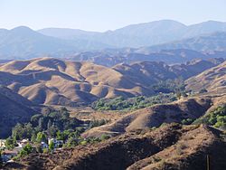
 View from Santa Clarita | |
| Highest point | |
| Peak | Burnt Peak[1] |
| Elevation | 5,791 ft (1,765 m) |
| Coordinates | 34°40′57″N 118°34′36″W / 34.6825°N 118.5768°W |
| Naming | |
| Etymology | Spanish for "Bald Mountains" |
| Geography | |
Location of Sierra Pelona Ridge in California [2] | |
| Location | Los Angeles County, California, U.S. |
| Parent range | Transverse Ranges |
The Sierra Pelona, also known as the Sierra Pelona Ridge[2] or the Sierra Pelona Mountains, is a mountain ridge in the Transverse Ranges in Southern California.[3] Located in northwest Los Angeles County, the ridge is bordered on the north by the San Andreas Fault and lies within and is surrounded by the Angeles National Forest and a tiny section in the Los Padres National Forest
- ^ "Burnt Peak". Peakbagger.com.
- ^ a b "Sierra Pelona Ridge". Geographic Names Information System. United States Geological Survey, United States Department of the Interior. Retrieved October 27, 2019.
- ^ U.S. Geological Survey Geographic Names Information System: San Gabriel Mountains

