Back ဝေင်ꩻနယ်ႏသိဉ်ပေါင်ဝဲ BLK ဆင်ပေါင်ဝဲမြို့နယ် Burmese သိၼ်ႇပွင်ႇဝႄး၊ ၸႄႈဝဵင်း SHN Sinbaungwe Swedish
Sinbaungwe Township
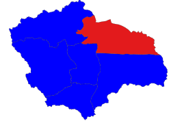
ဆင်ပေါင်ဝဲမြို့နယ် Sinbaungwé Township, Tantabin Township | |
|---|---|
 Location in Thayet district | |
| Coordinates: 19°33′N 95°23′E / 19.550°N 95.383°E | |
| Country | |
| Region | |
| District | Thayet |
| Capital | Sinbaungwe (Tantabin) |
| Time zone | UTC+6.30 (MST) |
Sinbaungwe Township or Tantabin Township (Burmese: ဆင်ပေါင်ဝဲမြို့နယ်) is a township of Thayet District in the Magway Region of Burma (Myanmar). It is located to the west of the Pegu Range in the foothills and on the plain of the Irrawaddy. Most of the township is east of the Irrawaddy, but about 20% of the township lies on the right (west) bank. The major town and administrative center is Sinbaungwe (Tantabin).
