Back سيني، كرواتيا Arabic Син (Хърватия) Bulgarian Sinj BS Sinj (lungsod) CEB سینی CKB Sinj Czech Sinj Danish Sinj German Sinj Spanish سینی، کرواسی Persian
Sinj | |
|---|---|
| Grad Sinj Town of Sinj | |
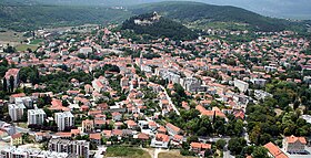
 Aerial view of Sinj | |
 | |
| Coordinates: 43°42′9″N 16°38′17″E / 43.70250°N 16.63806°E | |
| Country | |
| Historical region | Dalmatia |
| County | |
| Government | |
| • Type | Mayor-Council |
| • Mayor | Miro Bulj (Most) |
| • Town Council | 19 members |
| Area | |
| • Town | 193.4 km2 (74.7 sq mi) |
| • Urban | 7.7 km2 (3.0 sq mi) |
| Elevation | 326 m (1,070 ft) |
| Population (2021)[2] | |
| • Town | 23,452 |
| • Density | 120/km2 (310/sq mi) |
| • Urban | 10,771 |
| • Urban density | 1,400/km2 (3,600/sq mi) |
| Time zone | UTC+1 (CET) |
| • Summer (DST) | UTC+2 (CEST) |
| Postal code | 21230 |
| Area code | +385 021 |
| Vehicle registration | ST |
| Website | sinj |
Sinj (Croatian: [sîːɲ]) is a town in the continental part of Split-Dalmatia County, Croatia. As of the 2021 census, the population was 23,500 people, of which 10,800 inhabited its urban core.
Sinj is known for a knights' tournament of Sinjska alka,[3] which has been held since the beginning of the 18th century as a sign of victory over the Ottoman Empire, and for the shrine of Our Lady of Sinj. The urban center of Sinj is a protected cultural heritage site.[4]
- ^ Register of spatial units of the State Geodetic Administration of the Republic of Croatia. Wikidata Q119585703.
- ^ "Population by Age and Sex, by Settlements" (xlsx). Census of Population, Households and Dwellings in 2021. Zagreb: Croatian Bureau of Statistics. 2022.
- ^ "Sinjska Alka, a knights' tournament in Sinj". UNESCO Intangible Cultural Heritage. Retrieved 2024-03-22.
- ^ "Kulturno-povijesna urbanistička cjelina Sinja". Registar kulturnih dobara Republike Hrvatske (in Croatian). Retrieved 2024-03-22.
