Back ولاية سرداريا Arabic Sırdərya vilayəti Azerbaijani سیردریا ویلایت AZB Сырдар’інская вобласьць BE-X-OLD Сърдаринска област Bulgarian Сырдарьинан область CE Sirdaryo (lalawigan) CEB Sırderya vilâyeti CRH Viloyat Sirdaryo German Regiono Sirdarjo Esperanto
Sirdaryo Region
Sirdaryo viloyati | |
|---|---|
 Guliston Mosque | |
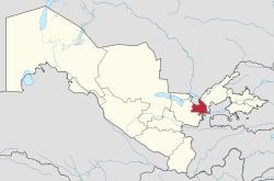
 Sirdaryo in Uzbekistan | |
| Coordinates: 40°25′N 68°40′E / 40.417°N 68.667°E | |
| Country | Uzbekistan |
| Capital | Guliston |
| Government | |
| • Hokim | Maxmudaliyev Akmaljon Azimjonovich |
| Area | |
| • Total | 5,276 km2 (2,037 sq mi) |
| Elevation | 267 m (876 ft) |
| Population (2021) | |
| • Total | 860,900 |
| • Density | 160/km2 (420/sq mi) |
| Time zone | UTC+5 (East) |
| • Summer (DST) | UTC+5 (not observed) |
| ISO 3166 code | UZ-SI |
| Districts | 9 |
| Cities | 5 |
| Townships | 6 |
| Villages | 75 |
| Website | sirdaryo |

Sirdaryo Region (Uzbek: Sirdaryo viloyati, Сирдарё вилояти) is one of the regions of Uzbekistan, located in the center of the country on the left bank of Syr Darya River. It borders with Kazakhstan, Tajikistan, Tashkent Region, and Jizzakh Region. It covers an area of 4,276 square kilometres (1,651 sq mi),[1] and is mostly desert, with the Starving Steppe taking up a significant part of the region's area. The population is estimated to be 860,900 (2021).[2]
The capital is the city of Guliston (pop. est. 91,300, 2021).[2] Other cities and towns include Baxt, Boyovut, Farhod, Qahramon, Sayxun, Sirdaryo, Khavast, Shirin and Yangiyer.
- ^ "Passport of the Syrdarya region". Officiel website of Sirdaryo Region. Retrieved 30 April 2018.
- ^ a b "Urban and rural population by district" (PDF) (in Uzbek). Sirdaryo regional department of statistics.