Back نهر سكونك ARZ Skunk River (suba sa Tinipong Bansa, Iowa) CEB Skunk River German Rio Skunk Portuguese
| Skunk River | |
|---|---|
 | |
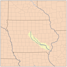
 Map showing the Skunk river, including both branches. | |
| Location | |
| Country | United States |
| State | Iowa |
| County | Lee County, Iowa, Des Moines County, Iowa, Poweshiek County, Iowa, Henry County, Iowa, Jefferson County, Iowa, Washington County, Iowa, Keokuk County, Iowa, Jasper County, Iowa, Story County, Iowa, Hamilton County, Iowa, Mahaska County, Iowa, Marshall County, Iowa |
| Physical characteristics | |
| Source | |
| • coordinates | 41°14′55″N 92°01′35″W / 41.2486246°N 92.0262877°W[1] |
| Mouth | Mississippi River |
• location | Burlington, Iowa, US |
• coordinates | 40°41′52″N 91°06′55″W / 40.6978186°N 91.1151447°W[1] |
• elevation | 518 ft (158 m)[1] |
| Discharge | |
| • location | Augusta, Iowa |
| • average | 2,809 cu/ft. per sec.[2] |
| Basin features | |
| Tributaries | |
| • left | South Skunk River |
| • right | North Skunk River |
The Skunk River is a 93-mile-long (150 km) tributary of the Mississippi River in the state of Iowa in the United States.